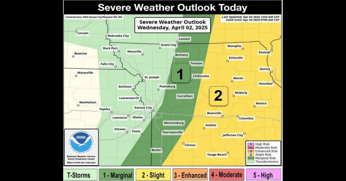
A line of severe thunderstorms continues to push through the Kansas City area Wednesday morning as parts of the metro remain under a tornado watch, according to the National Weather Service.
Downpours are also affecting the morning commute as the storms move through.
The tornado watch remains in effect until 10 a.m. for parts of Kansas and Missouri, including Johnson, Miami, and Wyandotte counties in Kansas and Cass, Jackson, Henry, Johnson, and Ray counties in Missouri.
A tornado warning was issued for parts of Cass, Henry, Bates, and Johnson counties in Missouri, which was in effect until 7:30 a.m. A tornado warning remains in effect until 8 a.m. for Windsor, Leeton and Calhoun in Missouri.
At 7 a.m., a severe thunderstorm capable of producing a tornado was located near Butler, moving northeast at 45 mph. Radar indicated rotation in the clouds.
People in the area were urged to take cover and move to a basement or interior room on the lowest floor of a building.
An urban and small stream flood advisory remains in effect for parts of Johnson, Miami, and Wyandotte counties in Kansas, as well as Cass, Clay, Jackson, Lafayette, Platte, and Ray counties in Missouri.
There was minor flooding in low-lying and poorly drained areas, with water over the roads in some locations.
“Be aware of your surroundings and do not drive on flooded roads,” the weather service said.
Second wave of storms moving through KC area
Two waves of thunderstorms are moving through as part of a large weather system that is sweeping across the central United States.
The first wave has already moved out, but the second one, which was more linear, is still affecting the area. The weather service said the main threat will be damaging winds, although hail is possible as well as an isolated tornado as the storm system moves further east into central and eastern Missouri.
“In addition to the severe risk, any training of storms from southwest to northeast could produce some localized excessive rainfall and flooding,” the weather service said. “Gusty winds are also expected today across the area with some gusts of 30 to 40 mph possible.”
Once the storms move out of the area, temperatures are expected to climb to the low 70s in the metro, which is about 10 degrees above average for this time of year in Kansas City.
Outbreak of tornadoes possible in eastern Missouri
The National Weather Service’s Storm Prediction Center issued a public severe weather outlook, stating that an outbreak of tornadoes and severe thunderstorms is expected over parts of the lower Mississippi Valley, the mid-South, and the lower Ohio Valley on Wednesday.
Areas under the outlook include parts of eastern Missouri, Tennessee, Kentucky, Illinois, Mississippi, Indiana, Louisiana, Ohio, Texas and Michigan.
“Numerous tornadoes, along with multiple long-track EF3+ tornadoes, appear likely,” the Storm Prediction Center said. “In addition, tornadoes, severe wind gusts, and very large hail will be possible across a broad area from north Texas northeastward to the southern Great Lakes.”
The Bootheel region of Missouri, Memphis, Jonesboro, Arkansas, Bartlett, Tennessee, and Southaven, Mississippi, are included in an area under a high risk of severe weather.
Rain chances continue in Kansas City’s forecast
The weather pattern is expected to remain active in the metro, with additional storms possible into the weekend. There is a high chance of rain Friday afternoon.
The rain chances will come to an end by the later half of the weekend, but not before cooler air filters into the region, the weather service said. There is a chance of a rain-snow mix on Saturday night into Sunday morning.
“There will be a frost/freeze potential as we head into Sunday night and Monday night as temperatures dip to freezing and slightly below both nights,” the weather service said. “The cooler air should be fairly short lived however as temperatures warm back into the 60s and70s by the middle of next week.”
