ALERT DAY: Tornado Outbreak looks likely across Alabama this afternoon and evening

THANK YOU SO MUCH FOR JOINING US HERE ON THESE STORMS WE HAVE MOVING THROUGH THE DAY TODAY HAVE THE POSSIBILITY OF REALLY PRODUCING SOME SIGNIFICANT DAMAGE. AND WITH THAT COMES JUST A LOT OF INFORMATION IN GENERAL. YES, A LOT OF MISINFORMATION. AND THIS IS WHY WE BROUGHT IN OUR WEATHER TEAM TO HELP CLEAR THE AIR A BIT. SO STEPH AND JORDAN, IT’S BELIEVED THAT THERE’S CERTAIN AREAS OF YOUR HOME THAT ARE BETTER TO BE IN THAN MOST DURING SEVERE WEATHER, PRIMARILY IN THE SOUTHEAST CORNER OF YOUR HOME. SO IS THAT THE CASE? THE BOTTOM LINE IS, AND ESPECIALLY LIKE TODAY, AN EVENT THAT WE ARE GOING TO SEE TODAY, WHICH DOESN’T HAPPEN VERY OFTEN, THE BEST ADVICE WE CAN GIVE YOU IS UNDERGROUND. GO UNDERGROUND. IF YOU HAVE A BASEMENT. IF YOU DON’T, IF YOU HAVE A FAMILY MEMBER OR A FRIEND THAT HAS A BASEMENT, THAT’S THE BEST PLACE TO BE. AND EVEN IF THAT’S NOT A POSSIBILITY, THEN YOU NEED TO START THINKING ABOUT A STORM SHELTER. THAT WOULD BE THE NEXT BEST PLACE TO BE. IF NEITHER OF THOSE ARE AVAILABLE TO YOU, DEFINITELY AN INNERMOST ROOM, AS MANY WALLS BETWEEN YOU AND THE OUTSIDE IS REALLY GOING TO BE THE BEST ADVICE THAT WE CAN GIVE YOU. BUT UNDERGROUND STORM SHELTER, THAT’S WHERE YOU NEED TO BE TODAY, OKAY? AND THEN EVERYONE NEEDS TO THINK ABOUT HOW MUCH TIME IT TAKES TO GET TO YOUR SAFE SPACE, RIGHT? YEAH. SO THESE STORMS POP UP QUICKLY WHEN THE ALARM GOES OFF. OR MAYBE YOU GET AN ALERT ON YOUR PHONE. HOW QUICKLY DO YOU NEED TO GET INTO THAT SAFE SPACE? YOU NEED TO BE FIVE MINUTES LESS THAN THAT. REALLY. WHEN THAT WARNING HAPPENS. THAT’S WHY WE SAY IF YOU ARE IN A MANUFACTURED HOME OR A MOBILE HOME, AND THAT WATCH IS ISSUED, GO AHEAD AND BE OUTSIDE THAT STORM SHELTER, RIDE IT OUT IN YOUR CAR. THEN WHEN THE WARNING, IF A WARNING WHICH THE ODDS OF THAT HAPPENING IS LIKELY TODAY THAN EVER, THAT’S WHEN YOU HEAD DIRECTLY INTO THE STORM SHELTER. THAT WAY, YOU’RE LESS THAN FIVE MINUTES ON THE WAY INTO THE STORM SHELTER. AND AGAIN, IF YOU KNOW SOMEONE WHO HAS A MANUFACTURED HOME OR A MOBILE HOME, NOW IS THE TIME TO GIVE THEM A CALL AND SAY, HEY, COME TO MY HOUSE. I HAVE A BASEMENT, RIDE IT OUT HERE. NO, POINT IS NOT TO SCARE YOU. IT’S TO PREPARE YOU AND YOU DO HAVE SOME TIME AND IT IS PRETTY CALM OUT THERE RIGHT NOW SO YOU CAN FIGURE OUT WHERE THAT SAFE SPACE IS. WE’VE BEEN THROUGH THIS BEFORE, RIGHT? WE WE KNOW THIS KIND OF WEATHER HERE IN ALABAMA. SO ALL WE HAVE TO DO IS BE PREPARED AND THEN JUST CARRY OUT THAT PLAN. THAT’S ALL WE HAVE TO DO FOR TODAY. WE’VE GOT A FEW HOURS. STILL, THESE ARE NOT EXPECTED TO MOVE IN UNTIL LUNCHTIME TODAY IN OUR WESTERN COUNTIES. SO YOU STILL HAVE A FEW HOURS TO GET THINGS TOGETHER. AND THEN IN YOUR PLAN KIND OF FINALIZED. SO ALL RIGHT, LET ME SHOW YOU THIS SKYCAM. THIS IS DOWN IN CHILTON COUNTY IN CLANTON, DOWN IN PEACH COUNTY. AND IF YOU LOOK CLOSELY, IT DOES LOOK PRETTY CLOUDY, BUT THERE ARE SOME SPOTS OF BLUE SKY. AND SO WE NEVER WANT TO SEE THE SUN COMING OUT, ESPECIALLY IN ADVANCE OF A DAY LIKE TODAY. BUT IT’S GOING TO HAPPEN. WE’VE ALREADY GOT SOME BREAKS IN THE CLOUDS THAT’S ONLY GOING TO ADD SOME EXTRA FUEL TO THE FIRE. I’VE GOT THE VISIBLE SATELLITE IMAGE IN HERE, ALONG OBVIOUSLY WITH THE RADAR DATA, BECAUSE I WANT TO SHOW YOU WHERE SOME OF THOSE BREAKS ARE. AND WE’RE REALLY CLEARING OUT DOWN HERE NEAR MONTGOMERY AND SOUTHEAST ALABAMA. I WOULD IMAGINE THEY’RE SEEING QUITE A BIT OF SUNSHINE THERE WHERE WE’VE HAD SOME RAIN THIS MORNING. SKIES ARE STILL PRETTY CLOUDY, BUT I SUSPECT THAT WE’RE GOING TO START TO REALLY SEE SOME OF THESE CLOUDS CLEARING THAT’S GOING TO SHOOT THE TEMPERATURES UP. AND WITH THOSE WINDS STARTING TO PICK UP AS WELL, WE’VE ACTUALLY GOT A WIND ADVISORY IN EFFECT WITH THOSE WINDS COMING IN OUT OF THE SOUTH. ALL OF THIS MOISTURE RICH AIR THAT WE SEE WITH THESE DEW POINT TEMPERATURES IN THE UPPER 60S, THAT’S ALL GOING TO ADVANCE OVER US HERE IN CENTRAL ALABAMA. AND SO ALL OF THE INGREDIENTS NECESSARY FOR THIS SEVERE WEATHER OUTBREAK ARE GOING TO BE COMING TOGETHER IN THE NEXT FEW HOURS. WE’RE GOING TO BE WATCHING THESE STORMS NOW THAT ARE SEVERE. SOME OF THEM TORNADIC, PRODUCING THUNDERSTORMS BACK ALONG THE MISSISSIPPI RIVER AND INTO LOUISIANA. AND THAT IS WHAT IS GOING TO BE HEADING OUR DIRECTION FOR LATER ON TODAY. A LOOK AT WHAT WE’VE GOT IN PLACE RIGHT NOW. A FEW SCATTERED SHOWERS, EVERYTHING BELOW SEVERE LIMITS HERE ON WVTM 13. LIVE DOPPLER UP HERE IN THE PARTS OF BLOUNT COUNTY SUMMIT SNEAD HEADING UP NEAR GUNTERSVILLE. WE’VE GOT A FLOOD ADVISORY IN EFFECT, AS WELL AS A FLOOD WARNING, A FLASH FLOOD WARNING FOR CULLMAN COUNTY. HERE IS A LOOK AT THE TIME. LINE 12 TO 9:00. SO NOON TO 9:00. HAMILTON, FAYETTE TUSCALOOSA RALPH FOSTER’S EUTAW FORKLAND BIRMINGHAM HOOVER UP TOWARD ONEONTA CULLMAN 2:00 TO 11:00 TONIGHT. AND THEN 4:00 TO 1:00 GADSDEN ANNISTON PIEDMONT. JACKSONVILLE TALLADEGA DOWN TOWARD MILLERVILLE AND ASHLAND. THOSE ARE THE KEY TIMES WHEN WE’RE EXPECTING THOSE TORNADIC PRODUCING THUNDERSTORMS TO BE ROLLING THROUGH JORDAN. THIS IS SERIOUS BUSINESS. AGAIN, WE’RE NOT TRYING TO SCARE PEOPLE. WE WANT TO PREPARE YOU SO THAT WHEN THEY ROLL IN, YOU CAN ACT QUICKLY. THAT IS RIGHT. AND WE’RE JUST LOOKING AT THOSE TIMINGS THAT YOU JUST MENTIONED AND ALL THAT INFORMATION, BY THE WAY, IS ON OUR WEBSITE, WVTM 13.COM. SO YOU FORGET THE TIMING OR MAYBE YOU MISSED IT JUST A SECOND AGO. YOU CAN GO THERE. EVERYTHING THAT WE’VE BEEN TALKING ABOUT TODAY IS ON THAT SITE, INCLUDING THE TIMING, THE IMPACTS AND HOW LARGE THAT RISK IS. BUT AS WE MAKE OUR WAY INTO THE NEXT FEW HOURS, WE GET A BREAK FROM THE RAIN. WE GET A BREAK FROM THE STORMS. NOW IS THE TIME. AS I MENTIONED EARLIER, IF YOU KNOW SOMEONE WHO LIVES IN A MANUFACTURED HOME OR MOBILE HOME, CALL THEM. IF YOU HAVE A BASEMENT, INVITE THEM OVER BECAUSE RIGHT NOW WE GET A BREAK FROM THE RAIN BETWEEN NOW AND ABOUT NOON. THEN WE HAVE SOME MORE STORMS COMING IN FROM THE WEST. AND CHECK OUT THESE WINDS ABOUT 5000FT UP IN THE ATMOSPHERE FROM WHERE I’M AT AND WHERE WE AT NOW. AND THAT’S WHAT’S DRIVING THE INSTABILITY TO CLIMB SIGNIFICANTLY. AFTER THE FIRST ROUND OF STORMS. AS THE SECOND ROUND COMES IN, ISOLATED CELLS ARE GOING TO START TO FORM. SOME OF THESE ARE GOING TO BE SUPERCELLS, MEANING WE COULD SEE SOME TORNADOES WITH THESE. AND WE’RE NOT JUST TALKING ABOUT THE RUN OF THE MILL TORNADOES. WE’RE TALKING ABOUT LONG TRACKED EF2 OR GREATER. THESE ARE SOME SERIOUS TORNADOES. IF AND WHEN THEY FORM. THIS IS 3:00 PM SATURDAY, AND WE AREN’T OVER WITH IT YET. THIS IS 4:00 PM. A MIX OF ISOLATED CELLS OUT AHEAD OF THE MAIN LINE, AND MORE OF A WAVE AND A CLUSTER, ALL OF WHICH HAVE THE POTENTIAL TO PRODUCE THOSE TORNADOES. THE DAMAGING WIND GUSTS BETWEEN 50 AND UP TO 70MPH, WHICH COULD KNOCK DOWN TREES, POWER OUTAGES MAKE SURE YOU CHARGE UP YOUR DEVICES, BUT MORE IMPORTANTLY, MAKE SURE YOU HAVE A WAY TO RECEIVE WATCHES AND WARNINGS. WE’VE BEEN TALKING ABOUT THAT ALL MORNING, AND WE’RE GOING TO CONTINUE TO TELL YOU THAT, BECAUSE THIS IS ONE OF THOSE DAYS WHERE WE TRULY MEAN IT. THIS IS 6 P.M. SATURDAY. WE’RE TALKING ABOUT WIDESPREAD COVERAGE OF SEVERE THUNDERSTORMS PRODUCING ALL THOSE SEVERE WEATHER PARAMETERS THAT I MENTIONED EARLIER. THIS IS THE TIME I THINK OUR MOST POPULATED COMMUNITIES AND ALL OF CENTRAL ALABAMA, IF NOT ALL OF ALABAMA, WILL HAVE THE HIGHEST CHANCE FOR SEVERE WEATHER. THIS IS 7 P.M. THIS CONTINUES, AND BY THE TIME WE GET INTO MIDNIGHT, THE SEVERE STORMS MOVE EAST. WE’RE LEFT WITH SOME SHOWERS, MAYBE THE OCCASIONAL THUNDERSTORMS, BUT WE CLEAR OUT BY 3 A.M. THAT’S WHEN THE SEVERE WEATHER THREAT IS OVER. UNTIL THEN, BE ON GUARD. THE TORNADO RISK FOR TODAY IS HIGHER THAN NORMAL. BY 3 P.M. WE’RE STILL IN THE HIGH END, AND THAT LASTS ALL THE WAY UP UNTIL ABOUT TEN, 11:00 TONIGHT. BUT EVEN THEN, THERE’S STILL A LOW WIND THREAT FOR A TORNADO HERE AND THERE. TODAY IS AN ALERT DAY. THAT MEANS THERE’S A HIGHER CHANCE THE WEATHER COULD BE LIFE THREATENING. THAT’S WHY WE ARE REALLY DRILLING IN HARD. HOW TO STAY SAFE AND WHAT YOU NEED TO DO TO PREPARE. AGAIN, ALL THE INFORMATION ON WVTM 13.COM. YOU’RE WATCHIN
ALERT DAY: Tornado Outbreak looks likely across Alabama this afternoon and evening
Updated: 8:39 AM CDT Mar 15, 2025
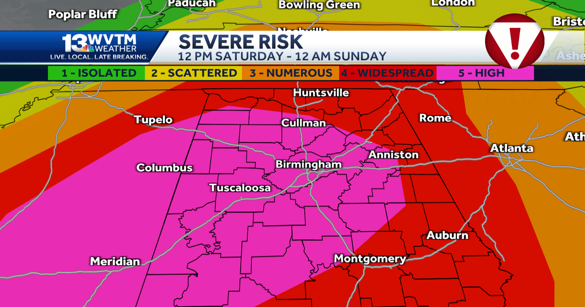
STATE OF EMERGENCY | STORM SHELTERS | WVTM 13 LIVE DOPPLER RADAR | UPLOAD YOUR WEATHER PHOTOS | WAYS TO STAY SAFE | GET WEATHER NOTIFICATIONS WVTM 13 meteorologists are tracking a severe weather outbreak in Alabama through Saturday with the threat of hail, damaging winds and tornadoes. ALERT DAY: Saturday, March 15 – a substantial threat of severe storms, including tornadoes, intense wind gusts and large hail in two main rounds.Below is the timeline.ALERT DAY: SATURDAYWe call a day an “Alert Day” when the weather could be life-threatening and you need to be aware of the latest changes.LOCATION:TIMING:There will be a round of storms ongoing Saturday morning in North and Central Alabama. These storms could have an impact on afternoon development, but we do not think they will be enough to stop the threat later in the day. A rough estimate of a timeline would start our “main” event as early as 11 a.m. Saturday THREATS:Saturday, March 15, will bring a significant risk of severe weather to the South including strong wind gusts over 70 miles per hour, large hail, and tornadoes. Some tornadoes could be strong and long-track (more than 15-20 mile path length). A system like this has the potential to be a higher-end severe weather threat in Alabama and Mississippi. Both supercells (individual rotating severe storms) and a squall line are possible in this kind of environment. Forecast guidance suggests the risk strong tornadoes, EF-2 or higher. From the SPC: “A tornado outbreak is likely on Saturday across the central Gulf Coast States and Deep South into the Tennessee Valley. Numerous significant tornadoes, some of which should be long-track and potentially violent, are expected on Saturday afternoon and evening. The most dangerous tornado threat should begin across eastern Louisiana and Mississippi during the late morning to afternoon, spread across Alabama late day into the evening, and reach western parts of the Florida Panhandle and Georgia Saturday night.”Be sure you have at least two reliable ways to get warnings and know what your plan will be if a severe storm approaches.The Weather Prediction Center outlines a moderate risk for flooding across Winston, Marion, Lamar, Walker, Blount, Cullman, and Etowah. Turn around don’t drown!CONFIDENCE:We have an unusually high confidence in the outcome of Saturday’s storm system because of the balanced look it shows in forecast model guidance. The setup has been presented in a very consistent manner showing the right balance of fuel (CAPE, instability) interacting with a strongly “sheared” environment (wind speed increasing and changing direction above the ground).These factors will likely make Saturday’s threat a “classic” severe weather setup for the South:(1) A strong jet stream in the right position. (2) A small but strengthening area of low pressure near Interstate 40 from Memphis to Nashville and a very strong “low level jet” (strong burst of wind about a mile above the surface).There are always things that can disrupt systems like this. Right now, we do not see anything that looks like a clear failure point. If it does come in balanced as we expect, this could be a very rough day in Mississippi, Alabama, Tennessee, and Georgia.The “Energy Helicity Index” shows just how balanced this looks. What does it mean?Think of it this way: if storms are happening in an environment like this, they have a high chance of being severe and capable of producing tornadoes. These two rounds of rain and storms also provide some hefty rainfall totals, and it could be enough for some flooding with isolated spots getting more than 2 to 3 inches.For the latest weather coverage for your area, click here. And stay updated with alerts in the WVTM 13 app. You can download it here.
BIRMINGHAM, Ala. —STATE OF EMERGENCY | STORM SHELTERS | WVTM 13 LIVE DOPPLER RADAR | UPLOAD YOUR WEATHER PHOTOS | WAYS TO STAY SAFE | GET WEATHER NOTIFICATIONS
WVTM 13 meteorologists are tracking a severe weather outbreak in Alabama through Saturday with the threat of hail, damaging winds and tornadoes.
- ALERT DAY: Saturday, March 15 – a substantial threat of severe storms, including tornadoes, intense wind gusts and large hail in two main rounds.

Below is the timeline.
ALERT DAY: SATURDAY
We call a day an “Alert Day” when the weather could be life-threatening and you need to be aware of the latest changes.
LOCATION:

TIMING:
There will be a round of storms ongoing Saturday morning in North and Central Alabama. These storms could have an impact on afternoon development, but we do not think they will be enough to stop the threat later in the day.

A rough estimate of a timeline would start our “main” event as early as 11 a.m. Saturday
THREATS:
Saturday, March 15, will bring a significant risk of severe weather to the South including strong wind gusts over 70 miles per hour, large hail, and tornadoes. Some tornadoes could be strong and long-track (more than 15-20 mile path length).

A system like this has the potential to be a higher-end severe weather threat in Alabama and Mississippi. Both supercells (individual rotating severe storms) and a squall line are possible in this kind of environment. Forecast guidance suggests the risk strong tornadoes, EF-2 or higher.
From the SPC: “A tornado outbreak is likely on Saturday across the central Gulf Coast States and Deep South into the Tennessee Valley. Numerous significant tornadoes, some of which should be long-track and potentially violent, are expected on Saturday afternoon and evening. The most dangerous tornado threat should begin across eastern Louisiana and Mississippi during the late morning to afternoon, spread across Alabama late day into the evening, and reach western parts of the Florida Panhandle and Georgia Saturday night.”
Be sure you have at least two reliable ways to get warnings and know what your plan will be if a severe storm approaches.

The Weather Prediction Center outlines a moderate risk for flooding across Winston, Marion, Lamar, Walker, Blount, Cullman, and Etowah. Turn around don’t drown!
CONFIDENCE:
We have an unusually high confidence in the outcome of Saturday’s storm system because of the balanced look it shows in forecast model guidance.
The setup has been presented in a very consistent manner showing the right balance of fuel (CAPE, instability) interacting with a strongly “sheared” environment (wind speed increasing and changing direction above the ground).
These factors will likely make Saturday’s threat a “classic” severe weather setup for the South:
(1) A strong jet stream in the right position.

(2) A small but strengthening area of low pressure near Interstate 40 from Memphis to Nashville and a very strong “low level jet” (strong burst of wind about a mile above the surface).

There are always things that can disrupt systems like this. Right now, we do not see anything that looks like a clear failure point. If it does come in balanced as we expect, this could be a very rough day in Mississippi, Alabama, Tennessee, and Georgia.
The “Energy Helicity Index” shows just how balanced this looks. What does it mean?
Think of it this way: if storms are happening in an environment like this, they have a high chance of being severe and capable of producing tornadoes.

These two rounds of rain and storms also provide some hefty rainfall totals, and it could be enough for some flooding with isolated spots getting more than 2 to 3 inches.

For the latest weather coverage for your area, click here. And stay updated with alerts in the WVTM 13 app. You can download it here.