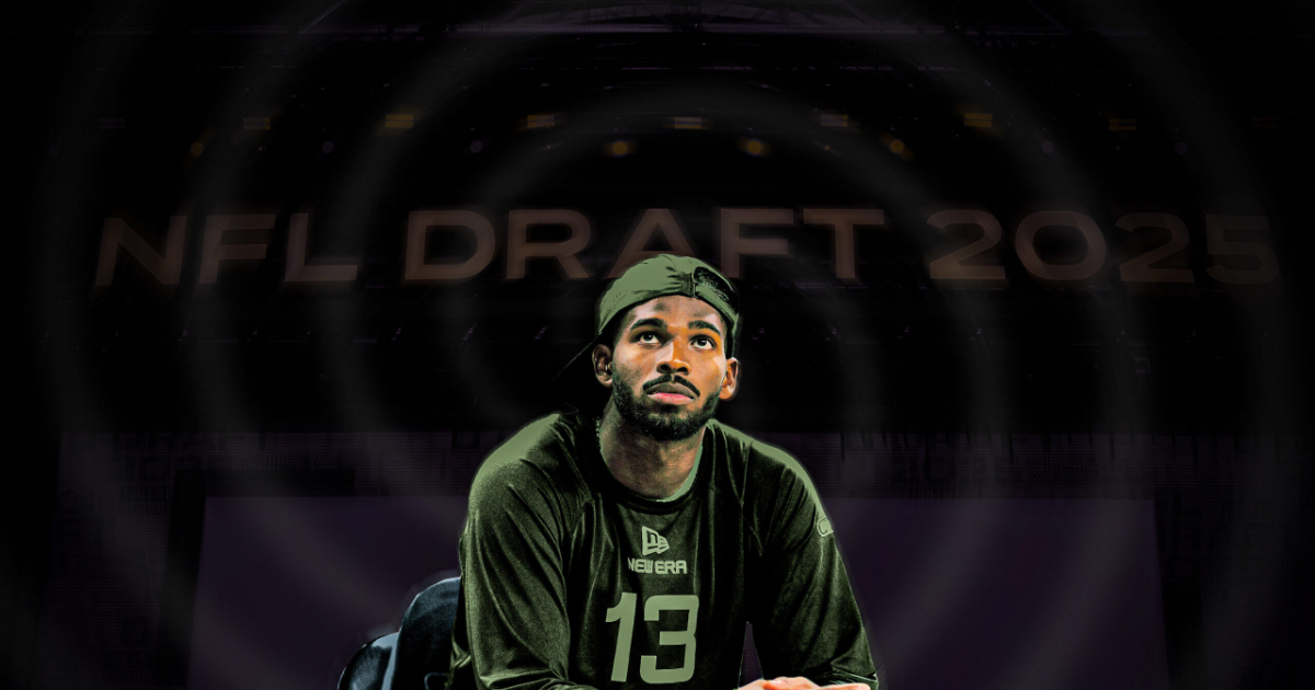
The NFL gave the Colorado quarterback a harsh reality check as he fell out of the first round of the draft. Which team will draft Coach Prime’s son on day two?
For the past few years, the Prime-industrial complex could put its thumb on the scale in favor of Shedeur Sanders.
Deion Sanders coached his son up in high school so he’d be ready for Division I college football. When the time came for college, Prime ensured there’d be a spot to be the starting quarterback on his team at Jackson State—and that he’d be paired with one of the best prep receiver prospects we’d ever seen in Travis Hunter. When all of them, the coach and players alike, were ready for a bigger program that was more likely to attract NFL attention, the Sanders family moved to Colorado. Shedeur received little blame for the Buffaloes’ struggles in his first year in Boulder, and last season Prime paired his son with a longtime NFL offensive coordinator, Pat Shurmur.
No matter what challenges Shedeur Sanders may have faced on his football journey to this point, he could count on his father to clear the way, control the conversation, and carefully manicure the possibilities for the future. Until Thursday night, that is, when not only was Sanders not the first quarterback selected in the first round of the NFL draft (that was Miami’s Cam Ward, at no. 1 to Tennessee), but also he fell out of the first round completely. The Giants even traded back into the first round, but took Ole Miss’s Jaxson Dart instead.
More From Round 1


More From Round 1
Until the NFL turned its collective nose up at the idea of Sanders as a top pick, there had never been a reason to consider that he wouldn’t land exactly where he and his family wished. There wasn’t enough consideration paid to how he’d come across in interviews, or whether he needed to work out at the combine, or if he’d have a good answer for the issues in his scouting report as a passer—he took 94 sacks in his final two collegiate seasons and an had average time to throw of 2.96 seconds, which would’ve ranked among the five slowest times among NFL quarterbacks in 2024. There were questions, too, about his arm, and whether he can throw hard enough to beat tight coverage in the NFL, or if he’s athletic enough to evade pro pass rushers.
As the first round played out, there were some impressive histrionics from draft and college football analysts as Sanders slid. ESPN’s Mel Kiper made several impassioned arguments for Sanders, Kiper’s top-rated QB, to be picked in the top three, then by New Orleans at no. 9, and again as Sanders fell into the 20s. Kiper compared his surprise over Sanders’s slide to how he felt about Aaron Rodgers, an absurd parallel to draw given the disparity in talent. Fox Sports’ Joel Klatt (who has inherent bias as a fellow Colorado quarterback), called the NFL “trash” for the information that was leaked about Sanders during the draft process, and said that the evaluation of Sanders’s personality “represents everything I dislike about the NFL draft.”
And still, no matter how much his biggest supporters pleaded, Sanders tumbled and tumbled and tumbled. It was tough enough when the Steelers passed. But then the Giants traded back into the first round, acquiring the 25th pick from Houston to get Dart. The Giants did a lot of work to scout Sanders, including putting the quarterback through a private workout and attending his pro day. But they, like the rest of the league thus far, seemed to conclude that Sanders’s physical tools weren’t impressive enough to merit a day one selection.
In hindsight, that doesn’t come as a huge surprise (though someone should tell that to Kiper, and whoever was in charge of ESPN’s statistical modeling). Sanders’s Colorado film made it difficult to picture him as an early pick. When I went through his throws midway through last season, I saw a quarterback who met the baseline threshold for accuracy and anticipation, enough to potentially be the top quarterback in this weak quarterback draft class. But by the end of the season, if you weren’t looking at him through Prime’s gold-tinted lenses, Sanders was pretty clearly a hypertrained quarterback—the kind who can fool you into thinking he is a high-floor prospect because he understands how to operate a pro-level passing game, but lacks the physical tools to actually pull it off in the NFL.
Sanders isn’t a twitchy runner and he doesn’t have great feel from the pocket. He is definitely tough—he routinely showed that in how he bounced back from punishing hits in most of Colorado’s games—but the Buffs’ poor offensive line is not an explanation nor an excuse for how many sacks he took. NFL evaluators have to be concerned that Sanders will be overwhelmed when pockets break down and he faces pressure in the pros. Recent quarterbacks who entered the league with better athletic traits (like Will Levis, Caleb Williams, and Justin Fields) or similar mid-level arm talent (like Bryce Young, Tua Tagovailoa, and Mac Jones) have struggled to run their respective offenses at times because of how often they’ve been hit.
With those sorts of on-field questions, for Sanders to have been a high pick he would have needed to convince teams he’d be the right personality to lead a locker room. The Ringer’s Todd McShay noted that teams didn’t leave their interactions with Sanders feeling like he was concerned about their evaluation of him, and Josina Anderson reported that NFL position coaches called him “brash” and “arrogant.” Ultimately, though, I think what contributed most to Sanders’s first-round fall came down to what was on tape.
The truth is, a quarterback’s personality matters little if he knows how to lead and perform under duress; and frankly, none of what we’ve heard about Sanders, outside of his Hall of Fame father, is that unique. Just last year, Caleb Williams was meticulously criticized for lots of things—his maturity and how he handled losing and even his personal style, and some of those conversations veered way too close to how a quarterback should project traditional masculinity. Still, Williams went first overall because nothing actually matters except being good at playing quarterback. That could’ve been the case for Sanders, had he shown enough on tape at Colorado.
Of course, all is not lost for Sanders. Cleveland still has a long-term quarterback need and owns two of the first five picks in Friday’s second round. The Rams, Seahawks, and Saints are other teams with multiple picks on day two and all of them are likely looking for a developmental quarterback. Sanders isn’t the only QB worth watching on Friday. Tyler Shough and Jalen Milroe, two prospects with better athletic traits and more impressive arms than Sanders, but worse pocket presence and accuracy, also were not picked on Thursday. If either of those prospects gets drafted before Sanders, we’ll get an even clearer sense of how critical the league is of Prime’s protégé.
In any case, Sanders almost certainly will get drafted on Friday; it’s just a matter of when, and to where, and then we can all start projecting what his NFL career might look like on his new team. But in prime time on Thursday, under the NFL’s biggest spotlight, the league wasn’t looking for Sanders, and his father couldn’t do anything to step in and save him.

Diante Lee joined The Ringer as an NFL writer and podcaster in 2024. Before that, he served as a staff writer at The Athletic, covering the NFL and college football. He currently coaches at the high school level in his hometown of San Diego.