Weather Alert:
SEATTLE – A severe thunderstorm watch is in effect until 9 p.m. for the following counties in WA: Clark, Cowlitz, King, Lewis, Pierce, Skamania, and King, and the following counties in OR: Benton, Clackamas, Columbia, Hood River, Linn, Marion, Multnomah, Polk, Washington, and Yamhill.
Download the free FOX LOCAL app for mobile in the Apple App Store or Google Play Store for the latest breaking news and weather alerts.
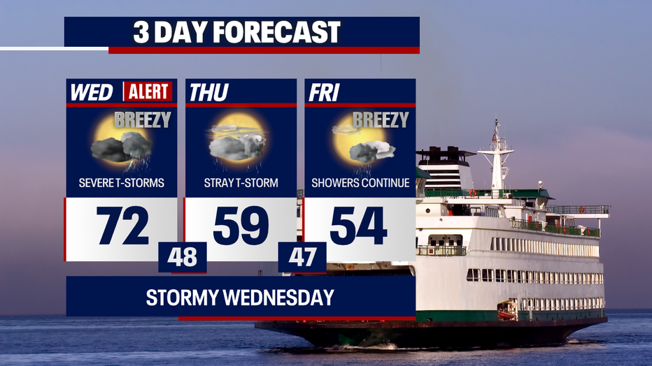
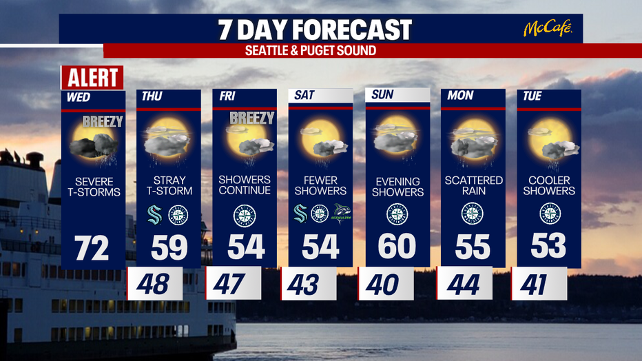
Severe weather forecast timeline
Timeline:
FOX 13 Seattle meteorologists are tracking an elevated threat for severe storms in western Washington on Wednesday evening with large hail, damaging winds, plentiful lightning and torrential rain possible. There’s even a low risk of a few tornadoes.
Strong to severe storms will be tracking from the south up to the north Wednesday evening. Storms could fire up as early as 4 p.m. to 5 p.m. near the Oregon state line before moving into the greater Seattle area by about 6 p.m.
Severe storm to hit Seattle Wednesday evening
Local perspective:
This is going to be a hit-or-miss situation. Some communities will get little to nothing while others could see highly impactful storms.
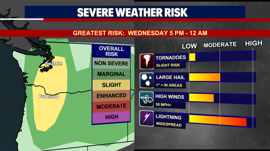
According to forecast models, western Washington is under a marginal to slight risk of severe storms. This is a Level 1 and 2, respectively, out of a 5-point scale. It’s incredibly rare for our region to see this type of weather pattern.
Why does western WA have the unique, rare threat of such intense storms?
The chance of seeing intense storms on Wednesday evening is due in large part to a big difference in temperatures between the surface and the higher levels of the atmosphere.
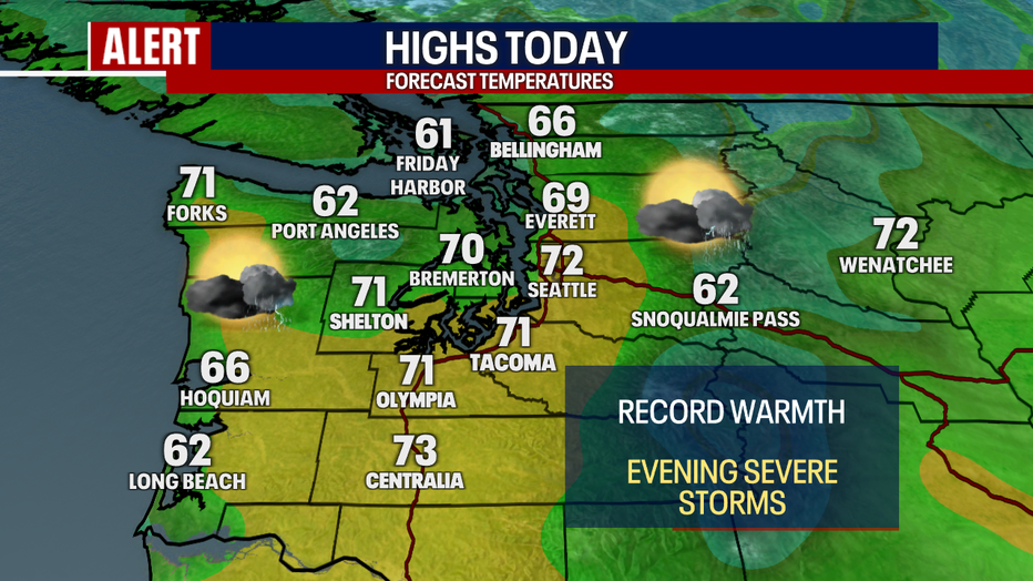
Bottom line: there is remarkably warm air closer to the ground. In fact, record-breaking temperatures are possible Wednesday afternoon. Highs could reach the low 70s once again. Meanwhile, an area of low pressure is brewing off the Washington coast. This storm system will be throwing cold, moist air aloft across western Washington and Oregon.
Hot air will rise, generating forceful updrafts. This will contribute towards large hailstones forming.
Hailstones and tornadoes in Washington
Dig deeper:
There is at least a 10% chance of hail two inches in diameter or greater in places including Seattle and Tacoma. Hail stones in some cases could be as large as golf balls – even tennis ball-sized hail is possible. See the image below for more details.

The tornado risk has increased to 5-9% for some areas of Lewis, Thurston, and Pierce counties. Should a tornado warning be issued (meaning, a tornado is imminent or already happening), take shelter immediately (read our safety tips below).
Localized flash flooding is possible in these strong thunderstorms. We also can’t rule out mudslides or debris flows off of burn scars in the mountains (which are previously burned areas from wildfires).
Powerful winds with gusts to at least 58 mph could develop as well.
What’s next:
After midnight, the chance of severe storms will drop. There could still be heavy rain, lightning and some gusts, but the threat for damages from some storms will decline.
On Thursday, there could be more thunderstorms; however, they’re not expected to be severe.
Here are my recommendations for your evening:
- If you can do so, get to your safe place by 5-6pm tonight to be conservative. If you’re able to do so, I’d recommend staying in one place until the severe threat is over by 10-11 p.m. (check the FOX Local app and radar through the night to see what’s happening and any active alerts!).
- If you have to be on the road and driving between activities tonight, ensure you have your emergency alerts turned on via your mobile phone.
- If you absolutely must be driving around the area tonight, know what to do when a severe thunderstorm warning or a tornado warning is issued. It’s dangerous to drive during severe weather. Be prepared to take cover in a sturdy shelter.
- Have multiple ways of receiving alerts tonight. Download the FOX Local app for your connected TV AND mobile phone for weather coverage! Download at least one other weather app, as well, to watch radar and alerts in your particular area.
- Only get your weather information from trusted sources!
- If a tornado warning is issued, and you don’t have a basement to go to, get to your lowest level and most interior room away from windows (e.g. a pantry, closet or hallway).
- If you can, park your car in a garage or under a covering to protect it from hail.
Take good care and stay safe,
Abby Acone and Brian MacMillan
The Source: Information in this story comes from weather models interpreted by FOX 13 Seattle meteorologists Abby Acone and Brian MacMillan.
MORE THUNDERSTORM NEWS FROM FOX 13 SEATTLE
Seattle bracing for ‘rare threat’ of severe thunderstorms on Wednesday
Seattle hailstorm warning: How to protect your car from costly damage
Tips to stay safe during a Seattle lightning storm
Wednesday storms bring risks of lightning, hail and damaging winds to western WA
Possibility of tornadoes in Washington Wednesday
To get the best local news, weather and sports in Seattle for free, sign up for the daily FOX Seattle Newsletter.
Download the free FOX LOCAL app for mobile in the Apple App Store or Google Play Store for live Seattle news, top stories, weather updates and more local and national coverage, plus 24/7 streaming coverage from across the nation.