COLUMBIA, S.C. (WIS) – While the bulk of the impactful weather from Tropical Storm Chantal will stay east of the Midlands, we will be tracking the chance of tropical downpours and breezy winds this morning, mainly east and northeast of Columbia.

wis(wis)
First Alert Headlines:
- Chantal to bring breezy winds and tropical downpours to the Midlands this morning, mainly for parts of Kershaw, Sumter, Lee, Clarendon, Calhoun, and Orangeburg counties.
- Drier, hotter weather moves in behind Chantal for early in the workweek.
- Rain chances trend up later in the week.
First Alert Summary:
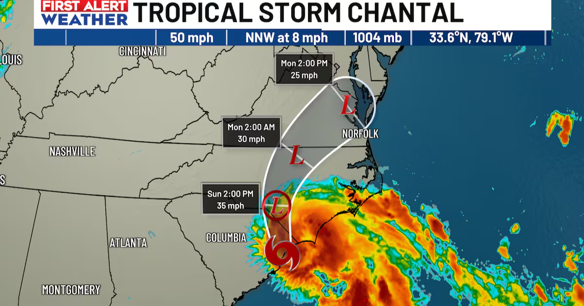
According to the National Hurricane Center, Chantal made landfall near Litchfield Beach, South Carolina at approximately 4 AM. The system will continue inland, weakening rapidly as it does so. It is forecast to move over the eastern Carolinas today and tomorrow.

wis(wis)
While most of the impactful weather with Chantal will be along the coast and for areas to our east, parts of the Midlands could feel some effects.
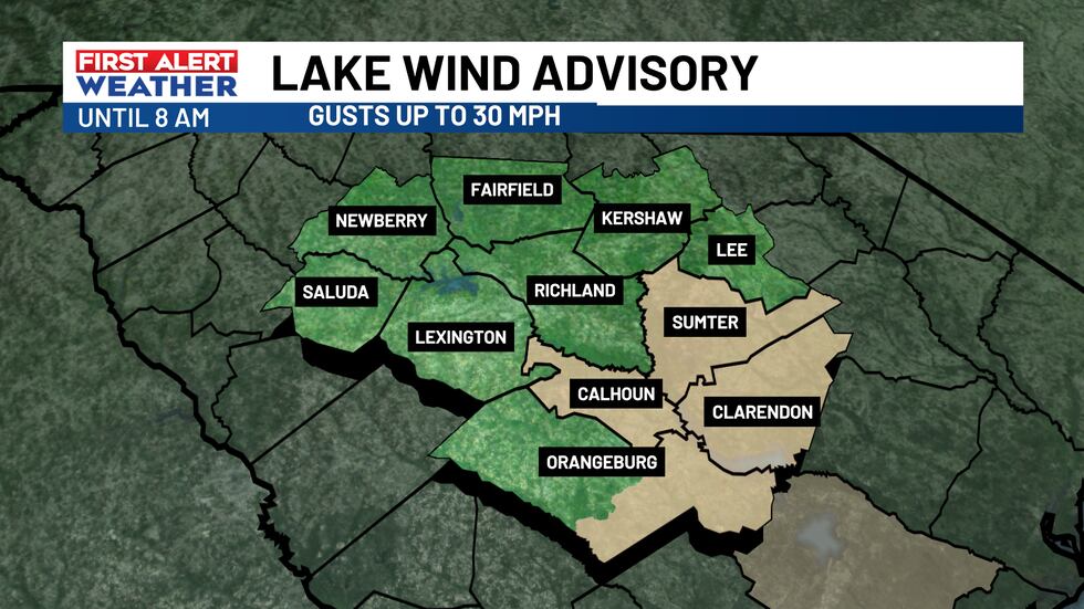
A Lake Wind Advisory is in effect until 8 am for our easternmost counties as winds there could gust to as high as 30 mph until about mid-morning.
wis(wis)
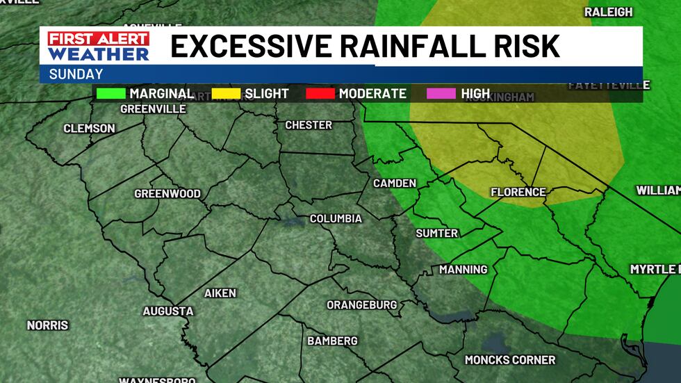
Those in the far eastern and northeastern Midlands will have a better potential of seeing tropical downpours and breezy winds. Gusts could be between 20-30 mph into Sunday morning. Chantal could also spread some showers and a few storms overhead, mainly across areas farther east and closer to the center of circulation. Some showers could contain locally heavy rainfall. Some minor flooding can’t be ruled out for areas that are low-lying and have poor drainage.
wis(wis)
The heaviest of the rain and higher wind gusts for parts of the Midlands should move out of the region by this afternoon with just a few passing showers remaining possible.

wis(wis)
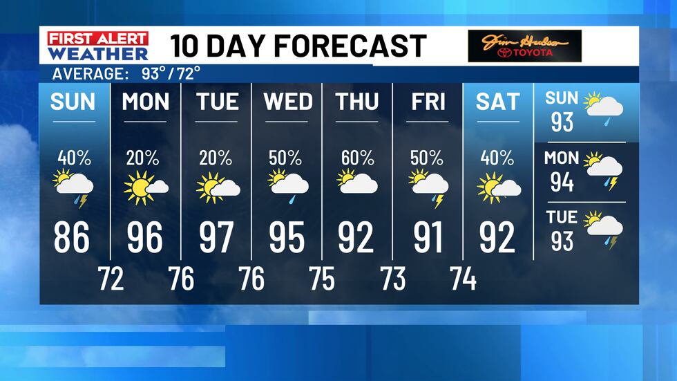
Drier air will quickly move in behind Chantal into early next week. We also expect temperatures to quickly heat up to the middle and upper 90s for the first half of the workweek.

wis(wis)
Another unsettled weather pattern will likely emerge by Wednesday and through next weekend. The forecast will consist of a daily chance of scattered showers and storms by this time.
First Alert Forecast:
Today: Mainly cloudy with highs in the middle 80s. Tropical downpours possible, mainly to the east and northeast. Breezy at times with gusts up to 20-30 MPH.
Monday: Mostly sunny. High temperatures warming up to the middle 90s.
Tuesday: Mix of sun and clouds. High temperatures in the upper 90s.
Wednesday: 50% chance of scattered showers and storms. Highs in the middle 90s.
Thursday: 60% chance of scattered showers and storms. Highs in the lower 90s.
wis(wis)
Feel more informed, prepared, and connected with WIS. For more free content like this, subscribe to our email newsletter, and download our apps. Have feedback that can help us improve? Click here.
Copyright 2025 WIS. All rights reserved.