Today will be another pleasant day with highs even warmer into the 70s this afternoon.Interactive Radar | Weather Alerts There will be more of a breeze with a 10-20 mph wind, but still a nice day to get out and about. High temperatures should top out around 75 degrees in the metro, well above average for this time of year.The south breeze will continue overnight, helping to keep temperatures mild into Friday morning. Low temperatures likely only fall into the mid-50s, staying above our average high for the middle of March.Friday will bring back the strong winds and severe thunderstorm threat. The strong area of low pressure that we have ben tracking all week will be approaching Iowa. As it gets closer, Friday morning will see increasing winds with gusts on the order of 35 to 50 mph by the lunch hour, which will last through the afternoon as well. Temperatures may be a few degrees warm than today, pushing into the upper 70s in the metro, with parts of eastern Iowa possibly approaching 80 degrees. The combination of very warm conditions, dry air, and gusty winds will produce high fire danger across the area.Thunderstorms are expected to rapidly develop during the afternoon hours, generally after 3pm. Storms initially form in far southern and southwest Iowa, and then race to the north and east at 50 to 60mph. That quick storm motion means storms will not last long in any one spot, but will pack a punch as they roll through.The quick movement of the storms will make it very easy for them to produce severe wind gusts on the order of 60 to 70mph. The high winds will be the main risk with any storms, though a few pockets of hail are possible, but should not be widespread. Once the storms start, they will organize into a line of storms that would favor those strong wind gusts. The good news is the tornado threat is on the low side for most of Iowa, though an isolated tornado can’t be completely ruled out, especially over eastern portions of the state. very dry air is expected to be in place at ground level, which is not favorable tornado formations. The highest threat for any tornadoes to spin up will be over the southeastern edge of the state and farther to the south and east into Illinois and Missouri. After the storms push out, the winds will bring in colder temperatures for the weekend. Expect another windy day Saturday with temps staying in the 30s and 40s along with a hard freeze for Sunday morning. Some lingering showers will be possible, but mainly in the morning hours on Saturday. The winds will downgrade to breezy on Sunday with mostly sunny skies and cool conditions. Temps will rebound for Monday. We are keeping an eye on an interesting system that could bring another round of rain and possibly snow mid-next week. Iowa weather forecast:Today: Mainly sunny. High 75F. Winds SE at 10 to 15 mph.Tonight: Some clouds. Low 56F. Winds SE at 10 to 15 mph.Tomorrow: Gusty winds with strong thunderstorms developing in the afternoon. Damaging winds and large hail with some storms. High 78F. Winds SSE at 25 to 35 mph.Tomorrow night: Cloudy with a few showers. Low 42F. Winds S at 15 to 25 mph.
DES MOINES, Iowa —Today will be another pleasant day with highs even warmer into the 70s this afternoon.
Interactive Radar | Weather Alerts
There will be more of a breeze with a 10-20 mph wind, but still a nice day to get out and about. High temperatures should top out around 75 degrees in the metro, well above average for this time of year.
The south breeze will continue overnight, helping to keep temperatures mild into Friday morning. Low temperatures likely only fall into the mid-50s, staying above our average high for the middle of March.
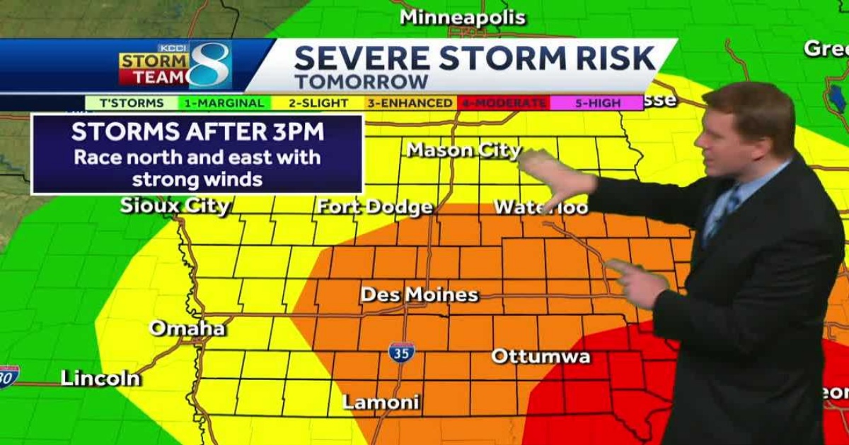
Friday will bring back the strong winds and severe thunderstorm threat. The strong area of low pressure that we have ben tracking all week will be approaching Iowa.

As it gets closer, Friday morning will see increasing winds with gusts on the order of 35 to 50 mph by the lunch hour, which will last through the afternoon as well. Temperatures may be a few degrees warm than today, pushing into the upper 70s in the metro, with parts of eastern Iowa possibly approaching 80 degrees. The combination of very warm conditions, dry air, and gusty winds will produce high fire danger across the area.

Thunderstorms are expected to rapidly develop during the afternoon hours, generally after 3pm. Storms initially form in far southern and southwest Iowa, and then race to the north and east at 50 to 60mph. That quick storm motion means storms will not last long in any one spot, but will pack a punch as they roll through.
The quick movement of the storms will make it very easy for them to produce severe wind gusts on the order of 60 to 70mph. The high winds will be the main risk with any storms, though a few pockets of hail are possible, but should not be widespread. Once the storms start, they will organize into a line of storms that would favor those strong wind gusts.

The good news is the tornado threat is on the low side for most of Iowa, though an isolated tornado can’t be completely ruled out, especially over eastern portions of the state. very dry air is expected to be in place at ground level, which is not favorable tornado formations. The highest threat for any tornadoes to spin up will be over the southeastern edge of the state and farther to the south and east into Illinois and Missouri.
After the storms push out, the winds will bring in colder temperatures for the weekend. Expect another windy day Saturday with temps staying in the 30s and 40s along with a hard freeze for Sunday morning. Some lingering showers will be possible, but mainly in the morning hours on Saturday. The winds will downgrade to breezy on Sunday with mostly sunny skies and cool conditions. Temps will rebound for Monday. We are keeping an eye on an interesting system that could bring another round of rain and possibly snow mid-next week.
Iowa weather forecast:
Today: Mainly sunny. High 75F. Winds SE at 10 to 15 mph.
Tonight: Some clouds. Low 56F. Winds SE at 10 to 15 mph.
Tomorrow: Gusty winds with strong thunderstorms developing in the afternoon. Damaging winds and large hail with some storms. High 78F. Winds SSE at 25 to 35 mph.
Tomorrow night: Cloudy with a few showers. Low 42F. Winds S at 15 to 25 mph.