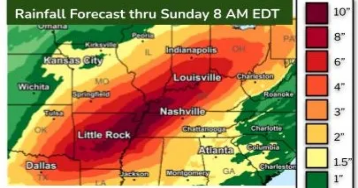
- Some areas could see up to four months’ worth of rain in just five days, leading to flash flooding in areas unaccustomed to such events.
- The rainfall is predicted to exceed 500 to 1,000-year averages, making it a truly historic weather event.
- The heavy rain is being caused by a “conveyor belt” of tropical moisture originating from the Caribbean.
Time to build an ark?
“Generational” rainfall amounts are forecast to fall across portions of the central U.S. from Wednesday to Saturday, resulting in historic and life-threatening flooding across the region, the National Weather Service in Memphis said.
According to AccuWeather, up to four months’ worth of rain will fall in five days along portions of a 1,000-mile-long swath from Texas to Ohio.
“People who have lived in a community their entire lives may see water rapidly rising and flooding areas they have never seen flood before,” AccuWeather chief meteorologist Jonathan Porter said. “Do not assume that if you have not seen flooding in an area before, that it will not occur this time.”
The heavy rain will occur in concert with a major severe weather outbreak that’s forecast for Wednesday in the central U.S.
How much rain will fall?
Up to a foot of rainfall is expected in just the next week from Little Rock to Memphis into Evansville, Indiana, said meteorologist Ryan Maue on X. Some spots along the Ohio River could see up to 15 inches, the weather service said.
Overall, Maue said that 76 trillion gallons of water is forecast to fall across the U.S. over the next week.
A 1 in 1,000 year rain event?
Small streams and drainage systems in urban areas will not be able to handle the surge of rainfall that’s expected. In extreme cases, rainfall rates of up to a few inches per hour can occur, which can lead to rapid flash flooding.
“Should the amount of rain occur that we anticipate over the middle of the nation, it would exceed the 500 to 1,000-year average,” AccuWeather meteorologist William Clark said, “Truly, the potential is there for a historic flash flooding event.”
Where and when will the rain fall?
“Rounds of rain will soak an area from northeast Texas to portions of the Mississippi and Ohio valleys beginning Wednesday and lasting into Saturday,” said Weather.com meteorologist Chris Dolce in an online forecast.
“That includes Little Rock, Arkansas; Memphis, Tennessee; Paducah and Louisville, Kentucky; Cincinnati and many other cities,” Dolce said.
Where is the worst flooding expected?
Flash floods: The repeated rounds of heavy rainfall over several days will create a widespread, significant flash flood risk, particularly focused on the Lower Ohio Valley, Mid-South and much of Arkansas, NOAA’s Weather Prediction Center said.
River floods: “The highest confidence for widespread significant river flooding (moderate and major) is from the eastern Ozarks through the lower Ohio Valley late this week through the weekend,” the Weather Prediction Center said.
Flood watch in effect for 26 million people
The National Weather Service has put a flood watch in effect for a huge chunk of the middle of the country, all the way from northeast Texas to northeast Ohio. In all, some 26 million people live where the flood watch is in effect.
What’s causing all the rain?
A conveyor belt of moisture will form this week, bringing many hours of heavy rain over multiple days from the Ozarks in Arkansas to the middle portion of the Mississippi Valley to much of the Ohio Valley.
“That moisture plume will be tropical in nature and originate from the Caribbean,” Clark said, “Tropical moisture raises the risk of excessive rainfall.”
