The 23 April 2025 earthquake appears to have ruptured a 20-kilometer-long section of the Marmara Fault, near the site of a 2019 magnitude 5.7 shock. Previous major events include earthquakes in 1509 and 1766.
By Ross S. Stein and Volkan Sevilgen, Temblor, Inc.
Citation: Stein, R.S. and Sevilgen, V., 2025, A magnitude 6.2 quake strikes the Marmara Fault at site of large historic earthquakes near Istanbul, Temblor, http://doi.org/10.32858/temblor.361
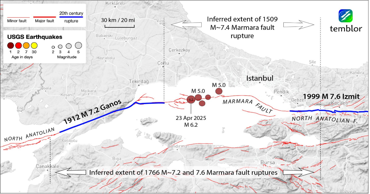
At 12:49 p.m. local time (09:49:10 UTC) on April 23, a magnitude 6.2 earthquake rocked Istanbul, prompting panic and injuries in the city of nearly 16 million people. The earthquake ruptured along the Marmara Fault — the 1,000-kilometer-long section of the North Anatolian Fault that transits through the Marmara Sea (Figure 1) — southwest of Istanbul. The shallow quake nucleated at a depth of about 11.5 kilometers, according to the U.S. Geological Survey, and 15.2 kilometers according to the Kandilli Observatory of Bogazici University in Istanbul.

Figure 1. The April 23 magnitude 6.2 earthquake struck along the central portion of the Marmara Fault, which was also the site of large shocks in 1509 and May and August 1766. The recent event is surrounded by ruptures of large shocks in 1912 (Aksoy, 2021) and 1999 (Parsons, 2004). Credit: Temblor, CC BY-NC-ND 4.0
Despite its distance from the shore, the earthquake was felt across the Marmara region, with widespread shaking of 10% of the force of gravity. In some isolated basins, this shaking reached 30% the force of gravity, similar to the force one feels in a car when you hit the brakes. The issue for this earthquake is not what it caused but what — if anything — it portends.
A Sea of faults
The Marmara Fault, a right-lateral transform fault, has a high slip rate of 23 millimeters per year (an inch a year). This is about the same slip rate as the San Andreas Fault in California, site of the 1906 magnitude 7.8 San Francisco shock, and the Saigang Fault in Myanmar, site of the magnitude 7.7 Mandalay shock on 28 March 2025.
But the long recorded history of earthquakes in the Marmara Sea affords us a much clearer picture of its past behavior than for most faults. In addition to shocks of about magnitude 7 in 1754 and 1894, there were much larger events in 1766 and 1509 in the mid magnitude-7 range, whose ruptures spanned between 150 and 260 kilometers. Since 1766, an approximately 160-kilometer-long section of the Marmara Fault has not ruptured — where stress is likely building.
Parsons (2004) estimated a 41±14% probability of a magnitude 7 or greater Marmara Fault earthquake affecting Istanbul during the period spanning 2004-2034. Presumably, this probability would be somewhat higher today, but no less uncertain.
Foreshock and aftershocks
The April 23 mainshock was preceded by a magnitude 4.0 foreshock 36 minutes beforehand, at the same location and depth, according to the Kandilli Observatory. Foreshocks precede about 5% of mainshocks globally and have not been shown to carry any special significance. The two magnitude-5 aftershocks thus far (Figure 1) are typical, or perhaps somewhat more productive than usual, for a magnitude 6.2 mainshock.
We can use the distribution of aftershocks to infer the length of the fault that ruptured during the mainshock. The Kandilli Observatory, whose seismic network can detect much smaller aftershocks than the USGS, show that aftershocks are concentrated over a 20-kilometer span, and a 20-kilometer-long rupture length is typical for a magnitude 6.2 strike-slip rupture (Blaser et al., 2010).
Are the adjacent 2019 and 2025 Marmara Sea quakes related?
The 2025 shock appears to have struck on the Marmara Fault itself, and is right-lateral. In contrast, the 2019 magnitude 5.7 shock struck on a reverse fault accommodating compression along a splay or branch off the Marmara Fault (Figure 2). So, are these related?

Figure 2. The 2019 and 2025 events lie just 8 kilometers apart, but on different fault strands and with different senses of fault slip. Becker et al. (2023) inferred the state of the fault based on the presence or absence of small ‘repeater earthquakes’ — sentinels of fault creep. Credit: Temblor, CC BY-NC-ND 4.0
In 2019, we published a calculation of the stress imparted by the September earthquake onto the Marmara Fault (Toda and Stein, 2019). We found that a portion of the Marmara Fault was brought significantly closer to failure. That section appears to correspond to the site of the magnitude 6.2 shock, although the calculation is sensitive to the focal depth of both shocks.
The Kandilli Observatory places the 2025 shock at 15.2 kilometers depth, in which case it was likely promoted by the 2019 shock, but the USGS assigns it a depth of 11.5 kilometers, where the stress increase is lower. So, we view this association as tantalizing but preliminary.
If the Marmara fault were to rupture, which way would it go?
In the unlikely case that the magnitude 6.2 shock proves to be a foreshock of an earthquake with a mid-7 magnitude, the direction of rupture propagation would matter; would it break toward Tekirdag to the west, or Istanbul to the east? Rupture direction also is important because the shaking tends to be stronger but briefer in the direction of rupture propagation.
Becker et al. (2023) built a precisely relocated catalog of Marmara Sea earthquakes, and then searched systematically for “repeaters,” small shocks that keep firing off in the same location with quakes of the same size. Studies elsewhere have shown that repeaters are associated with fault creep. Becker et al. (2023) used these observations to infer the state of the Marmara Fault, which we show in Figure 2.
If Becker et al. (2023) are correct that the 40-kilometer-long section to the west of the 2025 shock is creeping, it would be unlikely to propagate in that direction because creep would have relieved all or most of the stress. Thus, a rupture to the east — unfortunately toward Istanbul — from the transitional portion of the fault to the part that Becker et al. (2023) suggest remains locked, would appear much more likely. We know that transitional fault sections that partially creep can host large shocks, as occurred in the 1868 shock on the Hayward Fault with an approximate magnitude of 6.8.

Figure 3. After the September 2019 shock, Toda and Stein (2019) calculated the stress transfer to the Marmara Fault. The red patch depicts the portion of the fault brought significantly closer to failure, whereas the blue stress shadows show the portion of the fault brought further from failure. The 2025 shock appears to have struck in, or on the edge of, the promoted patch. Credit: Temblor, CC BY-NC-ND 4.0
Is the Marmara fault due?
It would be tempting to take the approximately 250-year span between the 1509 and 1766 earthquakes as the recurrence interval for magnitude 7.4 events on the Marmara Fault. In that were the case, then we have arrived at the time of the next great quake. But this view would be mistaken.
Hard-won seismic and paleoseismic records here and elsewhere reveal that earthquake occurrence is highly irregular, with the possible exception of the Alpine Fault in New Zealand (Berryman et al., 2012), which is much more isolated than most of the world’s great transform faults. So, we cannot speak of the Marmara Fault as being overdue. Rather, the 250 years of elapsed time since 1766 means that no one should be surprised if a large quake struck soon. It is possible, but not necessarily imminent.
Istanbul’s vulnerability
Istanbul lies 15 kilometers from the Marmara Fault — a relatively safe distance compared to Mandalay, Myanmar, which straddles the Saigang Fault that ruptured last month. But Istanbul experienced a massive burst of growth beginning in the 1960s, during which building codes were not followed, leaving the city very vulnerable today.
For a scenario magnitude 7.5 Marmara Fault earthquake, Erdik et al. (2004) estimated 30,000-40,000 deaths, 4,000-5,000 pancaked buildings, and another 35,000-40,000 buildings damaged beyond repair in greater Istanbul. Given Istanbul’s 16 million or so inhabitants, and the poor performance of multistory reinforced concrete apartment buildings in the 2023 magnitude 7.8 and 7.7 Kahramanmaras earthquakes in eastern Turkey, the Erdik et al. (2004) forecast no longer looks unreasonable; perhaps it is prescient. Thus, it seems inescapable that such an event would be disastrous for one of the most beautiful and historically important cities in the world.
References
Murat Ersen Aksoy (2021), The 9 August 1912 MürefteŞarköy earthquake of the North Anatolian Fault, Mediterranean Geosci. Rev., 3, 95–114, https://doi.org/10.1007/s42990-021-00050-z
Becker, D., Martínez-Garzón, P., Wollin, C., Kılıç, T., & Bohnhoff, M. (2023), Variation of fault creep along the overdue Istanbul-Marmara seismic gap in NW Türkiye. Geophysical Research Letters, 50, https://doi.org/10.1029/2022GL101471 and https://www.gfz.de/en/press/news/details/kriechen-und-verhaken-vor-istanbul-systematisches-bild-der-plattengrenze-im-marmara-meer
Berryman K. R. Cochran U. A. Clark K. J. Biasi G. P. Langridge R. M. Villamor P. (2012), Major earthquakes occur regularly on an isolated plate boundary fault, Science 336, 1690–1693, DOI: 10.1126/science.1218959
Lilian Blaser, Frank Krüger, Matthias Ohrnberger, Frank Scherbaum (2010), Scaling relations of earthquake source parameter estimates with special focus on subduction environment, Bull. Seismol. Soc. Amer., 100, 2914–2926. doi: https://doi.org/10.1785/0120100111
Erdik, M., Aydinoglu, N., Fahjan, Y. et al. Earthquake risk assessment for Istanbul metropolitan area. Earthq. Eng. Eng. Vib. 2, 1–23 (2003). https://doi.org/10.1007/BF02857534
Haluk Eyidogan and Volkan Sevilgen (2019), Strong earthquake strikes near the Marmara Fault, damaging 77 buildings and frightening Istanbul residents, Temblor, http://doi.org/10.32858/temblor.047
Kandilli Observatory and Earthquake Research Institute (KOERI) of Bogazici Uuniversity http://www.koeri.boun.edu.tr/scripts/lasteq.asp
Tom Parsons (2004), Recalculated probability of M ≥ 7 earthquakes beneath the Sea of Marmara, Turkey, J. Geophys. Res., 109, B05304, doi:10.1029/2003JB002667.
Toda, S., Stein, R.S., (2019), Could the 26 Sept 2019 Marmara Sea earthquake trigger a much larger event closer to Istanbul?, Temblor, http://doi.org/10.32858/temblor.046
Copyright
Text © 2025 Temblor. CC BY-NC-ND 4.0
We publish our work — articles and maps made by Temblor — under a Creative Commons Attribution-NonCommercial-NoDerivatives 4.0 International (CC BY-NC-ND 4.0) license.
For more information, please see our Republishing Guidelines or reach out to [email protected] with any questions.