April 3 (UPI) — At least five have died in Tennessee and one each in Missouri and Indiana as severe thunderstorms continue to move through the central part of the nation. The turbulence is expected through Sunday.
Local officials reported the deaths in several counties in western and south-central Tennessee, one in cape Girardeau County in southeastern Missouri and another in Hendricks County in southwestern Indiana — when a man touched a downed power line, USA Today and CNN reported.
At least one tornado touched down near Louisville, Ky., where a state of emergency has been declared.
The tornado struck Jeffersontown during the overnight hours and damaged several buildings, but no fatalities or injuries were reported, WDRB said.
Multi-day severe weather warnings
Additional storms are predicted and have triggered flood warnings in the greater Louisville area and throughout much of Kentucky. Weather forecasters are predicting up to 15 inches of rainfall in affected areas through Sunday.
“Intense rainfall rates, overwhelming rainfall totals and a surge of water moving downstream could lead to life-threatening flash flooding in places where people have never seen it flood in their lifetime,” AccuWeather Chief Meteorologist Jonathan Porter said.
“Much of Arkansas and the Ozarks region [and] the Mississippi Valley up to the Ohio Valley are in the bull’s-eye for the greatest risk of dangerous flash flooding,” Porter said in a news release shared with UPI.
“Many aging drainage systems in communities across the country were not built to handle this much rainfall,” Porter added.
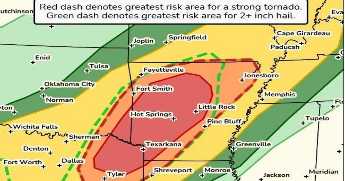
Clusters of severe storms that are capable of producing intense tornadoes, very large hail and wind damage will impact northeast Texas and southeast Oklahoma before moving into central Arkansas Friday afternoon and evening, according to the National Weather Service.
Clusters of super cells could produce EF2 to EF3 tornadoes and stronger with baseball-sized hail and isolated wind damage in those areas.
The NWS issued 728 severe thunderstorm and tornado warnings from 8 a.m. EDT Wednesday until 8 a.m. Thursday, which is the most in a 24-hour period in nearly 40 years, Weather.com reported.
The NWS advises those living in impacted areas to pay close attention to storm forecasts and updates and have a plan of action if any local watches or warnings are issued for severe weather.
The storms are disrupting air travel from Dallas to Washington, D.C., and causing localized flooding. More than 4,000 flights have been delayed due to the storms, CNN reported.
Millions at risk from severe weather
With more severe weather predicted through the weekend, more deaths could occur in the central United States.
More than 5 million are in areas subject to tornado watches in Arkansas, Mississippi, Tennessee and Kentucky.
Those seeking shelter from a tornado should go to the central area of a basement that is away from windows, and those who don’t have basements should seek shelter in an interior hallway, bathroom or closet that is away from windows, according to the NWS.
The storms also have caused numerous power outages and likely will cause more through the weekend.
Officials with the Federal Emergency Management Agency advise disconnecting electronics and appliances to prevent a power surge if the power goes out.
Freezers and refrigerators should stay closed to keep food products cold and any food that has warmed to more than 40 degrees should be thrown away.
People also should stay far away from any downed power lines to avoid electrical shock or electrocution and avoid using gas stoves to heat their homes, which could cause a fire dangers or carbon monoxide poisoning.
