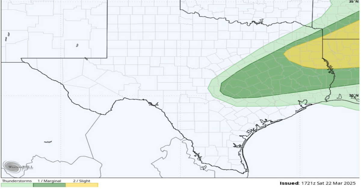
The severe weather outlook from the National Weather Service’s Storm Prediction Center shows a risk of scattered severe thunderstorms primarily north of the Interstate 10 corridor but close enough that Houston could see some storm activity.
WeatherBELL
Houston’s northern suburbs and those in the Brazos Valley and Piney Woods face a potentially active night of severe weather Sunday into early Monday.
The good news, in light of the Pauline Road wildfire that has burned more than 2,400 acres north of Houston, is that Southeast Texas is seeing moisture-rich, southerly onshore winds replace the dry air that helped wildfires spread across the state recently. The bad news is that the National Weather Service has warned that those same warm onshore winds could contribute to severe weather Sunday night.
The weather service’s Storm Prediction Center on Saturday showed a risk of isolated severe thunderstorms stretching from East Texas, then south to the northern edge of Harris County, and as far west as Austin along the Interstate 35 corridor. The strongest risk of scattered severe storms was centered in Northeast Texas, straddling the Texas-Louisiana border.
Article continues below this ad
“Sunday will feature a more active day than what we have seen in the last week,” weather service meteorologist Hayley Adams wrote in a forecast bulletin Saturday. She added that a system of low atmospheric pressure tracking east across the upper Midwest will “eject a cold front that will approach the Brazos Valley and Piney Woods during the evening hours on Sunday before stalling during the overnight hours Sunday into Monday.”
Houston temperatures on Sunday should start out at a balmy 65 degrees in the morning before soaring to 77 by noon and topping out around 83 by 5 p.m., according to the weather service.
Rain chances in Houston grow to 30% after 1 p.m. under mostly cloudy skies. South winds carrying tropical air from the Gulf of Mexico will be blowing at 10 to 15 mph, with gusts as strong as 20 mph. After midnight, rain chances bump up to 40% and the southerly winds shift to become easterly.
Shown here is the estimated rainfall accumulation in Southeast Texas from Sunday until 1 p.m. Monday, according to the National Blend of Models, a composite weather forecast model.
Pivotal Weather
“Showers will begin to move in from the Gulf and should be generally light,” Adams wrote in her short-term forecast. “As the daytime progresses, the axis of moisture convergence will move inland, as will showers.”
Article continues below this ad
Rain should be spotty at first, with the potential for isolated to scattered thunderstorms emerging by the afternoon, she added.
If thunderstorms do develop north of Houston, “they will have plenty of (atmospheric) instability and moisture to work with and will therefore have the potential to become strong to severe in nature,” Adams said. The main weather threats will be damaging wind and large hail that’s at least an inch in diameter.
Southeast Texas will continue to be dealing with scattered showers and possibly storms early Monday as the weak cold front crawls south across the region before moving offshore in the afternoon, the weather service said.
Houston on Monday will have a 30% chance of rain before 1 p.m. under cloudy skies. By the afternoon, skies will become mostly sunny and temperatures will peak at 84 degrees. The north winds behind the cold front will become easterly before nightfall.
Article continues below this ad
A cold front on Monday stretches from Texas to the mid-Atlantic states in this forecast map of the contiguous 48 states from the National Weather Service.
National Weather Service
Tuesday and Wednesday offer a mix of sun and clouds, but accompanied by generally benign weather with lows in the 60s and highs in the 80s, according to forecasters.
“Substantial rain chances return on Thursday as a mid/upper level shortwave trough digs through the desert Southwest towards Texas,” the weather service said Saturday in its long-term forecast.
A “shortwave trough” is a moving system of low atmospheric pressure that can push the warm air in front of it upwards. The water vapor in that warm air, if pushed high enough into the atmosphere, will condense into thunderstorms.
Article continues below this ad
This disturbance, the weather service said, could “bring fairly widespread rain chances across the region, beginning Thursday morning and continuing through Friday evening.”
“Overall, the end of the work week is shaping up to be wet,” forecasters said. “Locally heavy rainfall isn’t out of the question, though it’s a
bit too early to assess the full scope of this risk given the uncertainty and timing difference between (forecast) models.”