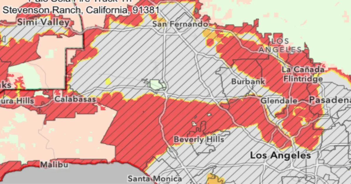
LOS ANGELES – Cal Fire just released their updated Fire Hazard Severity Zone Maps for Los Angeles County.
What we know:
The state goes through this process every ten years or so, and it’s meant not only to decide where resources are needed, but also to update clearance or home building requirements.
Identified hazard zones are divided into three levels — moderate, high and very high. The determination is made based on a variety of factors, including terrain, fire history, weather patterns and the presence of fire fuels such as thick vegetation.
Once the hazard zone maps are released by the state, local jurisdictions can adopt them or amend them by increasing the hazard level for particular areas. Local jurisdictions can not reduce the hazard levels from those recommended by the state.
>> Click here to view the updated maps <<
Dig deeper:
The LA County Board of Supervisors uses the standards for land use decisions and building standards. The county must act within 120 days to adopt the maps. The county is expected to schedule public hearings for people to comment on the proposed maps, but specific dates have not yet been determined.
According to the Los Angeles County Fire Department, the agency is not recommending any additions or increases in the Cal Fire hazard zone map. The agency noted that the updated maps likely mean an increase in the number of local parcels falling within hazard zones.
“These changes may influence building and vegetation management requirements for properties located within newly classified fire hazard zones,” according to LACoFD.
Fire officials say that insurance companies use their own metrics, but Supervisor Kathryn Barger argues the state needs to overhaul the system.
Many residents, especially those in the foothills, fear the maps will be used by insurance companies as one more reason to cancel policies.
The 2025 Local Responsibility Areas Fire Hazard Severity Zone maps are issued by the California Department of Forestry and Fire Protection (Cal Fire) and the Office of the State Fire Marshal.
SUGGESTED: LA Mayor issues executive order to expedite rebuilding in the Pacific Palisades
The urgency to release the updated maps comes from an executive order signed by Gov. Gavin Newsom last month, following the destructive Palisades and Eaton fires in January.
The backstory:
According to Cal Fire, the maps are developed using a “science-based and field-tested model that assigns a hazard score based on the factors that influence fire likelihood and fire behavior.”
“Many factors are considered, such as fire history, existing and potential fuel (natural vegetation), predicted flame length, blowing embers, terrain, and typical fire weather for the area,” according to the Cal Fire website.
SUGGESTED: SoCal Edison ‘zombie line’ may have sparked Eaton Fire: report
The maps cover cities and towns where local fire departments are responsible for managing wildfires. There is a separate map for parts of the state where Cal Fire is in charge. Federal lands are not included in the maps.
What they’re saying:
Last month, Gov. Newsom proclaimed a state of emergency to fast-track critical projects protecting communities from wildfire, ahead of peak fire season following the devastation of the LA firestorms and with the risk of wildfires increasing statewide.
“This year has already seen some of the most destructive wildfires in California history, and we’re only in March. Building on unprecedented work cutting red tape and making historic investments – we’re taking action with a state of emergency to fast-track critical wildfire projects even more. These are the forest management projects we need to protect our communities most vulnerable to wildfire, and we’re going to get them done,” Newsom said in a statement.
SUGGESTED: State Farm’s request for 22% rate hike in California approved
“California has experienced an increase in catastrophic wildfires over the past ten years,” Cal Fire Director Thom Porter said following Newsom’s proclamation. “The Procurement Sprint enables CAL FIRE to think outside the box and work with innovators from across the private, public and non-profit sectors to identify solutions to the challenge of detecting when a wildfire starts, and subsequently, where the fire will progress.”
Why It’s Important:
In the wake of the deadly January wildfires, the updated maps come at a time when the public’s concerns grow over wildfire risk.
SUGGESTED: Following the destructive LA wildfires, most residents haven’t considered moving: poll
The maps are important to identify areas most prone to burning and how to mitigate those risks.
The Source: Information for this story came from Cal Fire.