MYRTLE BEACH, SC (WMBF) – Tropical Storm Chantal is moving towards the South Carolina coastline, making landfall late tonight into early Sunday morning.
THE LATEST
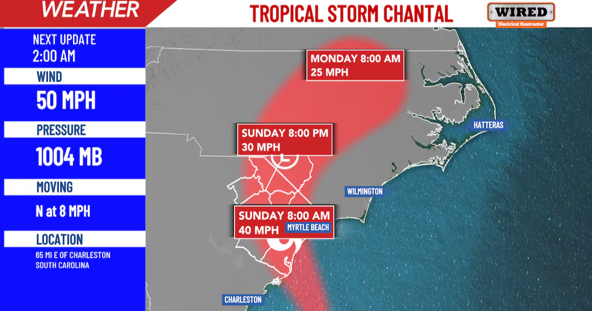
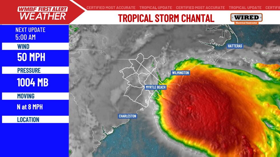
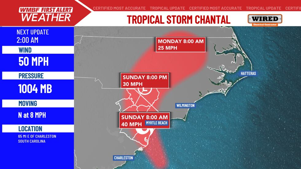
At 11 PM, the center of Tropical Storm Chantal was located near latitude 32.7 North, longitude 78.8 West. Chantal is moving toward the north near 7 mph. A motion toward the north-northwest is expected to begin this evening, followed by a turn to the northeast by Sunday night.
Tropical Storm Chantel(WMBF)
On the forecast track, the center of Chantal is expected to move across the coast of South Carolina overnight or early Sunday morning. Maximum sustained winds are near 50 mph with higher gusts. Some slight strengthening is forecast before Chantal reaches the coast. Rapid weakening is expected after landfall. Tropical-storm-force winds extend outward up to 140 miles primarily to the east of the center. The estimated minimum central pressure is 1004 mb.
Tropical Storm Chantel(WMBF)
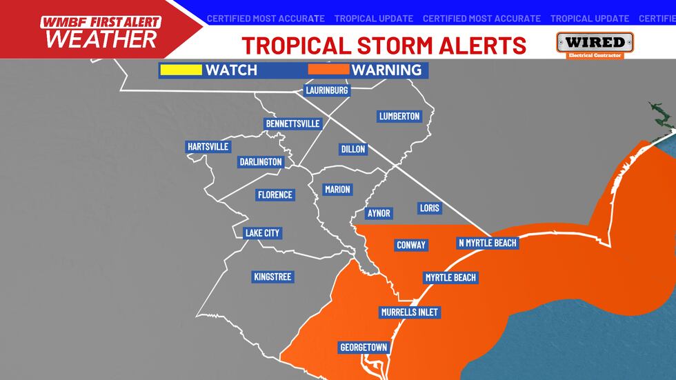
A TROPICAL STORM WARNINGS are in effect as Tropical Storm Chantal approaches the South Carolina coast. The warnings have now been pushing inland for Horry and Georgetown counties.
Tropical Storm Warnings are in effect(WMBF)
A Flood Watch has been issued for all of Horry County into southeastern North Carolina. Chantal will bring periods of heavy rain with 4 to 6 inches possible in some areas.
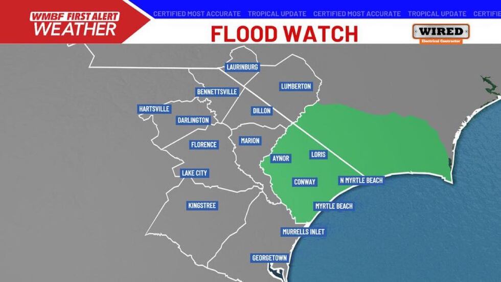
Flood watch issued ahead of Tropical Storm Chantal(wmbf)
POTENTIAL LOCAL IMPACTS
As the system nears the coast late this evening and overnight, increasing rain and gusty winds will develop and the risk of rip currents remains very high.
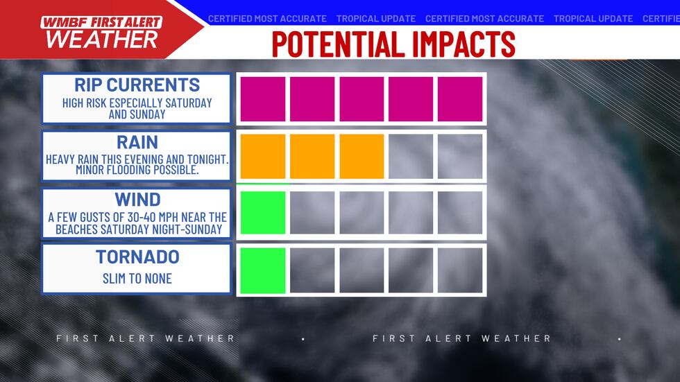
Heavy rain and rip currents are the main concerns with this system.(WMBF)
RAINFALL
A period of heavy rainfall will likely develop across the region late this evening and overnight. Rainfall amounts of 2 to 4 inches are possible across much of the area with isolated amounts of 6 inches possible.
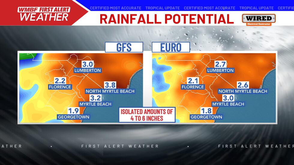
Totals of 2 to 4 inches are likely across much of the area. Isolated amounts of up to 6 inches will be possible.(WMBF)
While no significant or widespread flooding is expected, tropical downpours could lead to areas of minor flooding especially in flood-prone areas.
WIND
Wind will not be a major issue. Winds will turn increasingly breezy through the day. The peak winds arrive late this evening and overnight when gusts of 30 to 40 mph will be possible along the beaches.
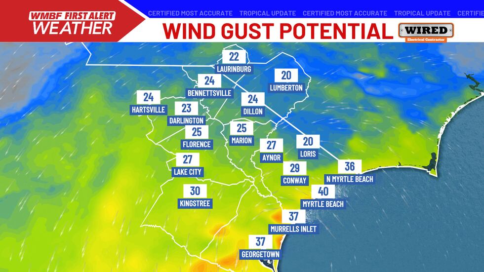
Wind gusts of minimal tropical force – near 40 mph will be possible near the beaches late this evening and overnight. No major wind issues are expected.(WMBF)
RIP CURRENTS
A high risk of rip currents remains in place today and again on Sunday.
TORNADO THREAT
We are watching for very low-end tornado threat late this evening and into the overnight as Chantal moves in. There is some spin in the atmosphere, so the storms that move onshore will have to be watched. Tornado Watches are NOT expected at this time, but we will continue to keep you update.
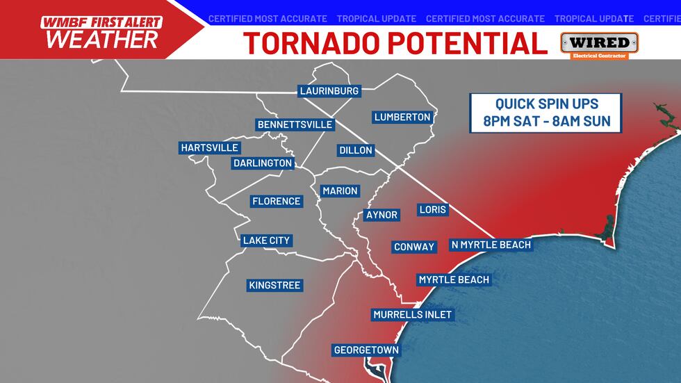
Quick spin up tornadoes cannot be ruled out, but remain on the low side for tonight.(WMBF)
STORM SURGE
An onshore flow ahead of landfall will increase the wave heights and push water into the Grand Strand. IF this lines up with the strongest winds near high tide, expect a storm surge potential for 1 to 3 foot, similar water levels to a normal king tides. High tide is set for 4:36 AM Sunday.
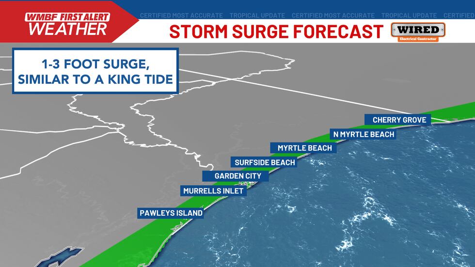
Onshore flow will increase throughout the night and if HIGH tide at 4:36 AM is paired with the strongest winds, a storm surge of 1-3 FT is forecast. Keep in mind, this is about what we see with King Tides.(WMBF)
Feel more informed, prepared, and connected with WMBF. For more free content like this, download our apps. Have feedback that can help us improve? Click here.
Copyright 2025 WMBF. All rights reserved.