A dangerous Saturday into Saturday night is set to unfold across the Deep South and into parts of the Southeast as a prolific tornado outbreak hits at least half a dozen states.
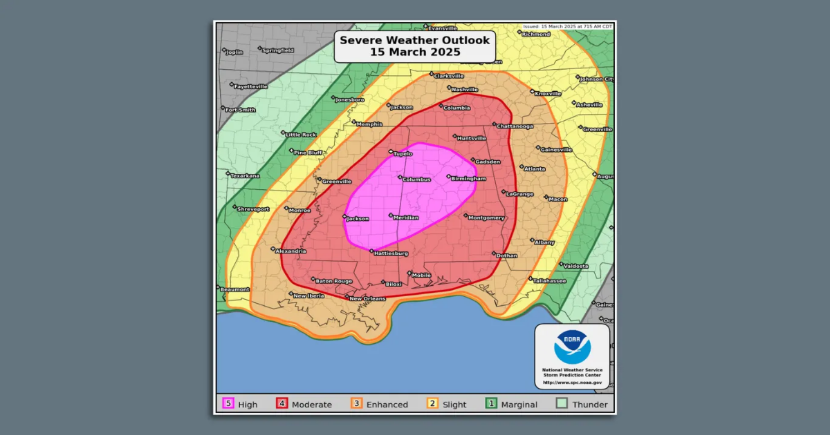
Threat level: The NOAA Storm Prediction Center has issued a rare “high risk” outlook indicating forecasters’ confidence in numerous, powerful tornadoes, particularly in parts of Mississippi and Alabama.
- The severe weather is forecast to get underway by late morning in Louisiana and Mississippi, with storms racing northeast with time.
- A mix of abundant wind shear, atmospheric instability and unusually strong upper level winds will drive this tornado outbreak, forecasters warned.
- The NWS forecast office in Birmingham released a statement on X Friday noting the rare combination of ingredients that could make this event so significant, summarizing it as: “This will be a very scary situation for many.”
State of play: A “Particularly Dangerous Situation” tornado watch is in effect until 6pm CT for much of Mississippi and northern Louisiana, for “numerous strong long-track tornadoes” as storms develop Saturday.
High risk region focuses on Mississippi and Alabama
The high risk zone (Level 5 out of 5 alert level) encompasses more than 3 million people on Saturday including the cities of Birmingham, Jackson, Miss., Tuscaloosa, Ala. and Hattiesburg, Miss.
- About 11 million people are located in the moderate risk zone (Level 4 out of 5 level) Saturday into Saturday night, including New Orleans and Baton Rouge, La., along with Montgomery and Mobile, Alabama and Columbus, Ga.
- Alabama Governor Kay Ivey (R) issued a state of emergency for the entire state on Friday.
- “The state of Alabama is at risk for potentially dangerous, severe weather throughout this weekend, so it is critical that everyone stays very aware of their local forecasts,” Ivey said.
Zoom in: The SPC is using strong language to describe the tornado threat in Louisiana, Mississippi and Alabama in particular on Saturday.
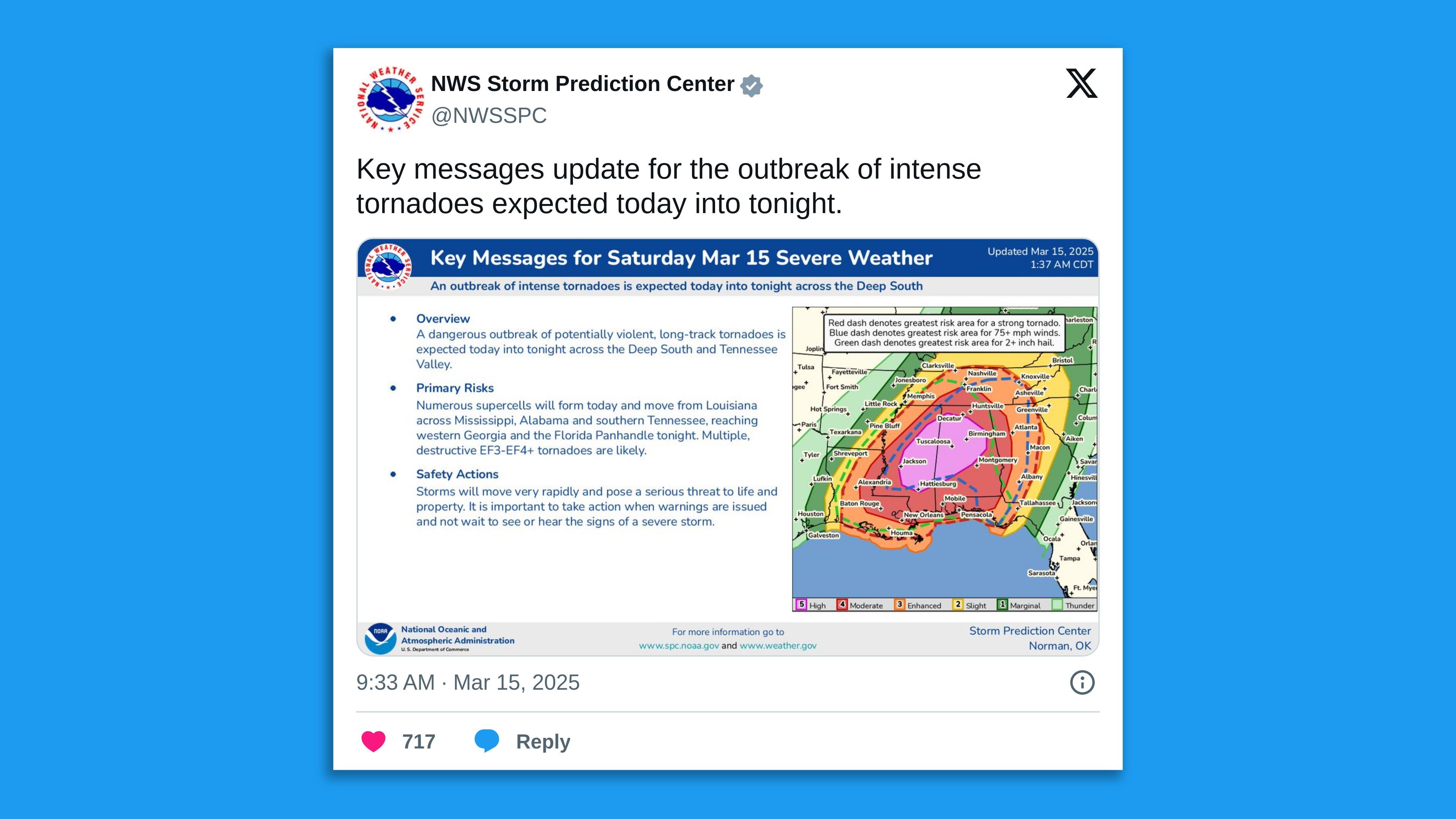
- “A tornado outbreak is expected across the central Gulf Coast States and Deep South into the Tennessee Valley,” SPC forecasters wrote in an online discussion Saturday morning.
- “Numerous significant tornadoes, some of which should be long-track and potentially violent, are expected this afternoon and evening.”
- The reference to “violent” tornadoes refers to twisters of EF-3 intensity or greater, and forecasters are also warning that some tornadoes may remain on the ground for many miles.
The tornado threat will continue into the overnight hours on Saturday into early Sunday, particularly in Georgia, parts of Tennessee and the Florida Panhandle.
- Overnight tornadoes are particularly deadly because people have a harder time receiving warnings and getting to shelter, particularly in states with high proportions of mobile homes.
NWS urges preparation for tornado outbreak
Zoom out: The storms on Saturday come after severe weather swept across the Mid-South and Midwest on Friday night, killing two in Missouri as about two dozen tornadoes were reported across multiple states.
 X/NWS Storm Prediction Center.
Context: Climate change is altering the environment in which severe thunderstorms and tornadoes form.
- Studies show that while some ingredients, such as humidity and atmospheric instability, are likely to increase with a warming climate, others may do the opposite.
- Climate change is anticipated to decrease the amount of wind shear available to severe thunderstorms, which could deprive them of a key ingredient for tornado formation.
Yes, but: When the right mix of ingredients are present, as they are on Saturday, climate change may lead to larger severe weather outbreaks.
The big picture: The NWS is urging people to prepare for the tornado outbreak, with some private sector forecasters instructing residents to be near tornado shelters by midday Saturday.
- Gather important documents, charge your devices, and do not hesitate to act when prompted,” the NWS forecast office in Birmingham stated in a forecast discussion.
- “These storms could be moving 50+ MPH when a warning is issued, and time will be of the essence.”
The intrigue: The Southeast has been particularly hard-hit by tornado outbreaks in recent years beginning during March.
Between the lines: This severe weather outbreak will test NOAA’s ability to handle a large-scale, potentially deadly weather event in the wake of laying off about 800 meteorologists and other staff in late February.
- These layoffs reduced staffing at some local weather forecast offices to threadbare levels, causing some to reduce their services.
- Some meteorologists are also having to put in more frequent overtime shifts.
The bottom line: This severe weather outbreak is likely to be a high-end, potentially historic event, resulting in multiple powerful, long-lasting tornadoes.
Go deeper:
What we know about how climate change affects tornado outbreaks
NOAA cuts could ground some Hurricane Hunter flights
2nd judge orders agencies to reinstate thousands of fired federal workers