More than 3.5 million additional acres across Southern California, including Los Angeles County, have been designated as fire hazard zones under updated maps released on Monday by the California Department of Forestry and Fire Protection (Cal Fire).
The maps, which represent the most significant update in more than a decade, expand “very high” fire hazard zones by 35 percent across local fire jurisdictions, increasing from 860,000 acres to almost 1.2 million, according to the Los Angeles Times. These zones require stricter building codes, defensible space mandates and disclosure requirements during real estate sales.
Why It Matters
Hazard severity zone maps are critical in California law, being cited in more than 50 sections. Properties in “high” and “very high” zones must adhere to fire-safe construction rules, such as installing multi-pane windows and ember-resistant vents, the Los Angeles Times reported. Homeowners in “very high” zones must also maintain defensible space and disclose the designation during property sales.

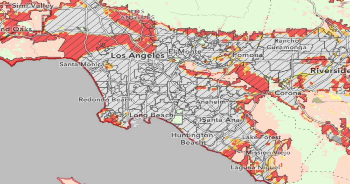
A screenshot of CAL FIRE’s fire hazard severity zone fire map showing the Los Angeles area, with “Very High” risk areas are depicted in dark red, “High” in orange, and “Moderate” in yellow. A screenshot of CAL FIRE’s fire hazard severity zone fire map showing the Los Angeles area, with “Very High” risk areas are depicted in dark red, “High” in orange, and “Moderate” in yellow. CAL FIRE
The maps seek to guide fire mitigation strategies in areas most at risk. However, analysis from CalMatters shows that the expansion also means that almost 1 in 10 Californians now live in zones where these rules apply, affecting home design, insurance availability and property values.
The area was ravaged by wildfires earlier this year, with tens of thousands of homes destroyed.
What To Know
In Los Angeles County alone, the updated maps add more than 440,000 acres to fire hazard zones, marking a 30 percent increase in the highest severity category.
The city of Los Angeles saw a seven percent rise in “very high” hazard acreage, while unincorporated areas of the county—home to communities such as Altadena, Santa Clarita and Puente Hills—experienced a tripling of their high-risk area designations.
Cal Fire’s new hazard maps conclude a two-month rollout, with the final installment covering all of Southern California. Local jurisdictions now have 120 days to collect public input and enact ordinances implementing the new classifications. Once adopted, fire safety regulations tied to the new designations are set to take effect after a 30-day period.
The updated maps are the result of improved modeling techniques, more refined data on climate and vegetation, and a 2021 state law requiring Cal Fire to include all three hazard levels—moderate, high and very high—in both state and local responsibility areas.
In cities such as Hesperia and Jurupa Valley, the “very high” hazard zones expanded more than 35- and 45-fold, respectively, the Los Angeles Times reported, while San Diego saw a 30 percent decrease in top-tier zones but an overall increase due to expanded lower-severity classifications.
What People Are Saying
U.S. Representative George Whitesides, a Democrat from California said in a statement, as reported by the Los Angeles Times: “Today’s release of updated hazard assessment maps from Cal Fire … underlines the ongoing wildfire crisis that California is experiencing…We must act fast and at scale to protect our communities and make sure insurance markets work for everyone.”
State Fire Marshall Daniel Berlant told CalMatters: “The reason we map these areas is to tie these really important wildfire mitigations to them, helping us to ensure that as we build out new communities we’re building to the level of hazard that exists, giving them an increased chance of surviving a wildfire.”
What Happens Next
Local governments must now review the updated maps and adopt new ordinances. They can increase, but not decrease, the severity classifications. The new rules are expected to be enforced later this year after the local adoption process concludes.