MINNEAPOLIS (FOX 9) – A damp Tuesday with occasional rain showers will transition into slushy accumulating snow by the evening, which could make for a messy morning commute on Wednesday
Timeline of what to expect
Timeline:
A storm system developing to the south will create occasional rain showers during the day on Tuesday before transitioning to slushy snow Tuesday night. Here’s what to expect.
- Morning: A mild start on Tuesday with temperatures in the mid-40s and chances for pocket light drips.
- Afternoon: Damp with scattered light rain showers as winds begin to increase.
- Late afternoon: The rain begins to flourish, becoming heavier and more widespread with a wet start to the evening commute.
- Evening: Gusty winds as temperatures slide toward freezing with the rain mixing with some snowflakes during the later evening commute.
- Overnight: Wet slushy snow falls, heavily at times, with gusty winds upwards of 45 mph, leading to low visibility and very difficult travel.
- Wednesday morning: Heavy snow tapers to lighter snow and then flurries through the morning commute with difficult travel continuing as many areas start the clean-up process.

Weather advisories and warnings
What to expect:
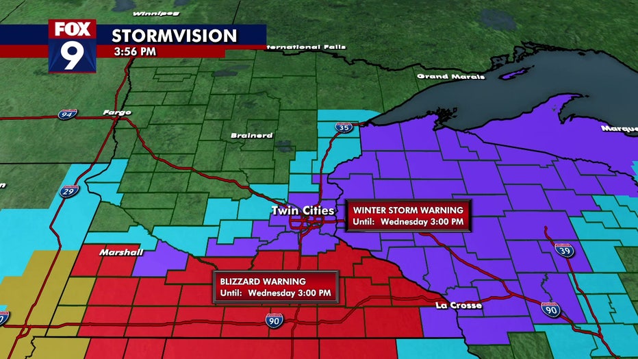
The National Weather Service has issued a blizzard warning for southeastern Minnesota with wind gusts reaching 55+ mph and several inches of accumulation possible.
The Twin Cities metro is under a winter storm warning, with wind gusts expected to reach 45+ mph. Meanwhile, parts of central and southern Minnesota are under a winter weather advisory. These warnings and advisories will be in effect from 6 p.m. Tuesday until 3 p.m. on Wednesday.
Southeastern Minnesota and western Wisconsin are expected to see the highest snowfall totals, with pockets of 6 to 8 or more inches. In the Twin Cities metro, the northwest side could receive 2 to 4 inches, while the southeast side could get more with 4 to 6 inches likely. Central Minnesota, west of the metro, will receive lighter totals with an inch or two possible.
Messy Wednesday morning commute
What’s next:
The overnight snow will likely create a slushy and slippery commute for drivers across the Twin Cities metro and much of southern and eastern Minnesota as well as western Wisconsin on Wednesday morning. The snow will wrap up by the lunch hour for a sunny afternoon with highs in the 30s.
The rest of the week will be calm, with highs in the 30s, warming into the 40s over the weekend and reaching the 50s by next week.
Track the snow storm
What you can do:
FOX 9 will be tracking the storm as it moves in overnight. We will have live coverage through our evening shows and then in the overnight hours starting at 2 a.m.
You can watch all of our local coverage on Wednesday and beyond on FOX Local. Learn how to download it to your smart TV or through Roku, Amazon Fire Stick, Apple TV, and other services by clicking here.
School closings
What’s next:
Due to the snow, several districts in southern Minnesota have closed for Wednesday, March 5.
Here is a full list of school closings. Please refresh your page for the latest closings.
Weather ForecastMinnesotaWinter Weather
