Fire hazard has grown in Los Angeles County over the past decade, according to new state maps. The Office of the State Fire Marshal found that the land area considered to have “very high” fire hazard severity jumped more than 30% since the last assessment in 2011.
More LA County land has ‘very high’ fire hazard severity under new state maps
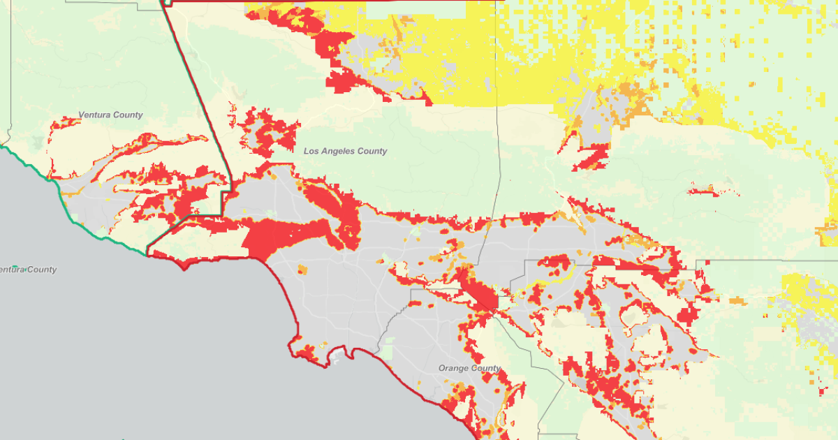
The Fire Hazard Severity Zone maps, published Monday for Southern California, show fire hazard creeping farther into some of L.A.’s most populous areas.
“Very high” fire hazard severity now extends north of Ventura Boulevard in some parts of the San Fernando Valley, across San Vicente Boulevard farther into Santa Monica, and south of Sunset Boulevard in West Hollywood.
The results will have implications for future building requirements in areas deemed to be a high fire hazard and will mean fire mitigation requirements for some property owners who are newly designated in the highest severity areas, according to CalFire.
Property owners in “very high” severity zones are required by law to maintain 100 feet of defensible space around their home, essentially creating a barrier to slow down or stop a fire from spreading.
According to an FAQ from CalFire, the model used to determine fire hazard primarily looks at “probability of an area burning and expected fire behavior under extreme fuel and weather conditions.” For the first time, the maps also show “moderate” and “high” hazard levels.
“Very high” fire hazard means the areas with highest probability of fire and the potential highest intensity, according to CalFire Chief Jim McDougald.
How January’s fires factor in
The maps don’t take into account recent wildfires, such as the devastating Eaton and Palisades fires that killed 29 people and destroyed more than 16,000 buildings in January. But the increased fire hazard does come amid increased anxiety about the scope and peril of wildfire risk in Southern California after those devastating events.
“Very high” fire hazard has also expanded in Altadena and Pasadena, according to CalFire’s maps. But it did not reach as far into Altadena as the Eaton Fire spread.
“Before these maps were produced, I thought the very high fire severity zones were really gonna reach down deep, deep down into Altadena. And they haven’t,” L.A. County Fire Deputy Chief Albert Yanagisawa said.
CalFire Chief McDougald said that’s because their models look at wildland fires, not “urban conflagrations.” According to CalFire, the model does take into account the initial potential spread of embers, which can “travel long distances in the wind and ignite vegetation, roofs, attics (by getting into vents) and decks.”
But McDougald clarified that they did not look at what happens once “houses become the fuel” for a fire.
“ We do not model what happens if a fire starts from those embers and how it burns through the homes,” he said.
What happens next?
The Southern California maps are the last to be published in a series of releases from CalFire looking at areas in the state that are the responsibility of local fire departments. Across Southern California, very high fire severity hazard zones have increased 26%.
McDougald said the maps are reflective of greater fire hazard over recent years, but also better mapping of where the burnable vegetation is, where embers may land during a fire and localized weather reports.
“Over the last 10 years, fire has increased across the state. And I’d say these maps are much more reflective of what we’ve been seeing,” he said.
These maps now go to local municipalities for adoption. L.A. County Fire Deputy Chief Yanagisawa said in a news conference that the Fire Department is reviewing the data after receiving it Monday morning.
CalFire and a release from California Insurance Commissioner Ricardo Lara said the hazard maps aren’t meant to influence insurance companies, which assess risk when setting rates.
Check your home
You can search your address and check out the map yourself here.