LOS ANGELES (KABC) — Severe fire hazard zones blanket parts of Southern California on new state maps published Monday – the first release of its kind in 14 years – as fire officials rush to keep up with the impacts of climate change on the southland.
Following the Los Angeles wildfires in January, Gov. Gavin Newsom issued an executive order expediting an overhaul of Cal Fire’s outdated wildfire hazard maps. The data was published in batches over the past two months, from North to South down the state, with Monday’s maps marking the long-awaited completion of the project.
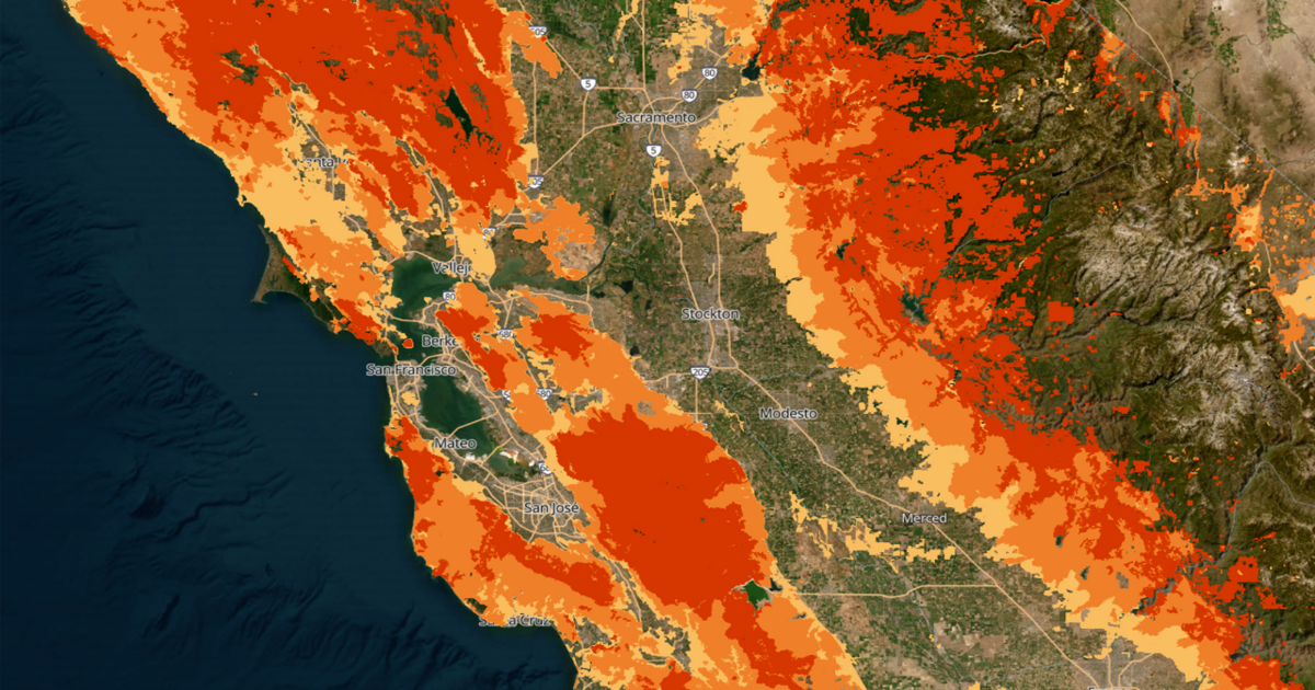
The end-result is stark: millions of acres of “very high fire hazard” zones running up and down the Golden State.
“The sheer number of more cities and areas that are now being designated in a fire hazard severity zone goes to show just how serious of a wildfire problem we have,” State Fire Marshal Daniel Berlant told Eyewitness News. “And I don’t need to tell residents in L.A. that there’s a problem.”
The new maps incorporate information on topography, fire weather, flame length, past fire history, vegetation type and the overall likelihood of a wildfire igniting in the area.
“Embers are one of the leading causes of homes that are destroyed by wildfires,” Berlant said. “In this model, we’re able to determine how many embers are going to be produced, and then under the weather conditions, where will that ember go.”
Berlant said the maps, as concerning as they are, reflect the realities firefighters already know to be true – climate change is increasing the fire hazards across California.
California updated its fire hazard maps for the first time in more than a decade, resulting in millions of acres of “very high fire hazard” running up and down the Golden State.
With the new maps, cities and counties can now set new home hardening and brush clearance requirements to prepare the state for the changing climate. Homeowners can also use these maps to assess their own risk and take potentially life-saving steps to make their properties more fire resistant.
“We really hope that these maps are a call to action for many Southern California residents,” Berland said. “Maybe now they’ll take steps to be prepared.”
See where your home fits in
The ABC Data Team found 900,000 acres of land now fall into Greater Los Angeles’ “very high hazard” fire zones – a 29% increase from the old 2011 maps.
The hazardous areas, marked in an ominous bright red on Cal Fire’s maps, ballooned by many thousand acres in Chino Hills, Hesperia, San Juan Capistrano, Santa Clarita and Palmdale.
Now, 43 new cities in the greater Los Angeles region appear on the maps that didn’t before. That includes Lancaster, which now has 16,000 acres of “very high hazard” territory, plus another 20,000 acres in the new “high hazard” and “moderate hazard” categories established by Cal Fire.
Graph not displaying correctly? Click here to open in a new window
The City of Los Angeles saw a 7% increase in the “very high” zones, but there was virtually no change in the Pacific Palisades, where the Palisades Fire leveled hundreds of homes in January. That’s because Cal Fire had already identified the serious hazards posed by the Santa Monica Mountains on the 2011 maps.
In Altadena, an unincorporated part of L.A. County that faced the worst of January’s Eaton Fire, the hazard zones crept inward from the North and the West. Close by, the zones now border the Rose Bowl and the 710 freeway in Pasadena.
“I encourage everyone, especially those in high fire areas, to review these maps and to stay informed,” said Supervisor Kathryn Barger, whose district includes the Eaton Fire burn area, in a Monday press conference.

Barger said her office is still reviewing whether the maps could slow down rebuilding in the burn zones, but she vowed that it wouldn’t interfere with the permitting process. Though no permits have been granted yet, Barger said she will post an update online by the end of the week.
State and local governments have 120 days to officially adopt the maps, and they have the right to add – but not remove – more fire hazard territory in the process. L.A. County is already reviewing them, and the public will have an opportunity to comment before the maps are adopted.
“At this time, we are not proposing increases,” said L.A. County deputy fire chief Al Yanagisawa. “But that could change.”

Implications for homeowners
At a minimum, state law requires homeowners in very high fire hazard zones to clear brush and potential ignition sources within 100 feet of the home, or up to the property line. For new properties in high hazard zones, developers will have to follow California regulations on fire-resistant building materials. The same is generally true for homeowners looking to make substantial additions to their existing homes.
Berlant, the state fire marshal, estimates that 90% of existing homes in wildfire-prone areas were developed well before today’s building standards. Cal Fire is now working with local fire departments to educate homeowners on steps they can take to make their older homes more fire resistant.
As for insurance impacts, Cal Fire stresses that rates should not climb as a result of the new maps. Insurance companies already rely on sophisticated risk modeling that factors in climate and fire conditions when setting premiums.
That’s not to say premiums won’t go up. Insurance experts told Eyewitness News that the Palisades and Eaton fires will result in higher costs for home insurance across the region, and fewer insurers offering coverage in fire-prone areas.
Rick Dinger, the president of Crescenta Valley Insurance, says clearing brush and home hardening – actions Cal Fire hopes become more common with the release of these maps – can also help when shopping for insurance policies.
“They want to see all kinds of data in order to approve the house,” Dinger said. “It’s no longer, ‘Sure, we’ll insure it.’ Insurance carriers have gotten more sophisticated and more disciplined in their underwriting in order to make sure that they’re protecting their investment.”