As a winter storm arrives in Minnesota, projected snow totals are starting to be revised upwards in the Twin Cities.
The band of the heaviest snow expected to fall mostly overnight has shifted north, and is now encompassing a chunk of the Twin Cities, which is currently in the 7-11 inch zone.
As BMTN meteorologist Sven Sundgaard points out in his earlier forecast, whether that’s the amount on the ground come Wednesday morning depends on how much melting and compaction happens overnight, with the system bring heavy, wet snow to the state.
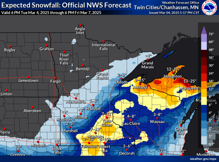
NWS Twin Cities
While there remains uncertainty about the final totals due to the melting/compaction, what’s not in dispute is how dangerous the roads are expected to be during the Wednesday morning commute, with many school districts already canceling classes in anticipation.
The National Weather Service says there will be dangerous blizzard conditions in south-central and southeast Minnesota as heavy snow is joined by wind gusts upwards of 50-55 mph.
“It’s important to note that even 3″ of snow with the powerhouse 50-55 mph gusts will produce dangerous conditions, so this is not a winter storm scenario to take lightly,” the NWS said.
In the Twin Cities, the combination of heavy snow and strong winds will create “hazardous, though sub-blizzard, conditions in eastern Minnesota and western Wisconsin.”
“That being said, gusts between 40-45 mph are still capable of producing brief white-out conditions that will combine with accumulating snow to create very challenging travel conditions,” the NWS forecast discussion reads.
The winter storm warning goes into effect in Redwood, Minnesota in the west at 9 p.m. Thursday and expires at Barron, Wisconsin in the east at 3 p.m. Wednesday.
The heaviest snow in the Twin Cities is expected between midnight and 6 a.m.