A radar-confirmed tornado was spotted whirling through counties just south of Atlanta as strong storms barreled through the metro area Monday.
Channel 2’s Chief Meteorologist Brad Nitz noted the rotation on the radar in eastern Coweta County crossing into Fayette County around 12:45 p.m. No significant damage was reported in Fayette, officials said, but it was not immediately clear how hard Coweta may have been hit.
Tornado warnings have popped up and quickly expired across the metro region throughout the early afternoon. Departures to Hartsfield-Jackson Atlanta International are grounded at least through 2:15 p.m., and the airport advised travelers to check for updated flight information.
“This is a rapidly developing and rapidly moving tornadic thunderstorm,” Nitz said.
While Fayette seemingly escaped severe damage, it “did experience a brief period of strong winds and there are some sporadic power outages,” Emergency Management Agency Director Brian Davis said.
As of 1:30 p.m., Georgia Power said more than 12,200 customers across the state were without power, including about 8,000 in metro Atlanta.
The state’s electric membership cooperatives have reported more than 9,500 outages; more than half are situated in the metro area.
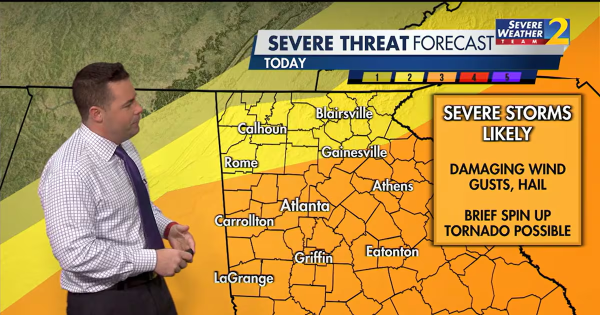
The line of strong to severe storms marched into Georgia from the west, with the worst expected to hit the city between 1-2 p.m., according to forecasters. Western parts of the metro area started experiencing rain in the late morning.
A severe thunderstorm watch has been issued for parts of North and Middle Georgia through 7 p.m., according to the Weather Service.
The timing of the storms is coinciding with the day’s peak heat, “so there will be plenty of energy for these storms as they come on through,” Channel 2 Action News meteorologist Brian Monahan said.
ExploreFive safety tips to prepare for severe storms, tornadoes
Highs on Monday are expected to reach 72 degrees around the city.
Much of the state, including metro Atlanta, is under a Level 3 of 5 risk for severe weather, according to the National Oceanic and Atmospheric Administration’s Storm Prediction Center. North of the metro area, there is a Level 2 risk, and locations along the Tennessee border are under a Level 1 risk.
The storms are bringing heavy rain and damaging wind gusts of up to 60 mph, warned Nitz.
Gusts that strong could bring down trees, branches and power lines. And while the storms will be “heavy rainfall producers,” there shouldn’t be much of a threat for flash flooding as showers should move quickly, according to the NWS.
The heaviest part of the storms should be out of the area by about 5 p.m., with scattered showers lingering after that. Another punchy storm is expected to reach the city by about 7 p.m., though, just as a cold front arrives.
That storm should be on its way out by 9 p.m. Behind that, cooler, drier air will move into North Georgia, the NWS says.
After a chilly morning with temperatures in the 40s, “a dry, sunny Tuesday is in store with springlike afternoon highs in the 70s and 80s,” the Weather Service predicts.