A severe weather outbreak is taking shape across the central and eastern United States, setting the stage for a weekend of thunderstorms, hail and potential tornadoes.
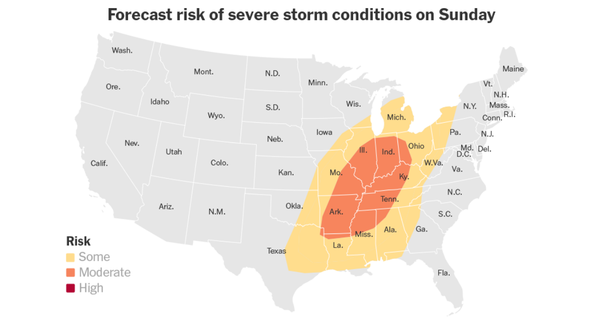
- Widespread storms are expected to sweep through a region stretching from Texas to Michigan on Sunday. Some of the most severe weather is expected in the Ohio and Tennessee River Valleys, where forecasters said the conditions are right for “very large hail, damaging winds and strong tornadoes.”
- By Monday, the threat is forecast to move east, affecting a region that stretches from the Southeastern states through the Mid-Atlantic and Northeast.
The volatile setup is driven by a cold front that is linked to a storm system moving through the Great Lakes and will collide with warm, moisture-rich air in the South, creating the prime conditions for powerful thunderstorms.
“To the warm side of that front in the south, we’ll have enough moisture and instability to get thunderstorms, and some of them could be severe,” said Marc Chenard, a meteorologist at the Weather Prediction Center.
Severe weather could begin Saturday night in the Midwest, bringing the biggest risk of large hail and strong wind gusts from northeastern Oklahoma through eastern Kansas and western Missouri. However, the threat is expected to become more widespread on Sunday and Monday.
The highest risk on Sunday is concentrated over northern Louisiana, Arkansas, northern Mississippi, northwest Alabama, western Tennessee, southeast Missouri and much of Kentucky, Illinois, Indiana and eastern Ohio.
These areas have been placed under an enhanced risk level, three out of five by the Storm Prediction Center. Forecasters warn that “all severe hazards are possible,” including large hail, tornadoes and damaging wind gusts.
On Sunday, the threat of severe weather is expected in the afternoon, from eastern Texas to parts of the Mississippi, Ohio and Tennessee River Valleys.
The risk will spread eastward through Sunday evening across portions of the Ohio Valley and mid- to lower Mississippi Valley, before transferring southeastward into the Tennessee Valley and central Gulf Coast States on Sunday night.
While the primary dangers will come from powerful thunderstorms, hail and tornadoes, some regions may experience excessive rainfall on Sunday and Monday, in an area from Louisiana, Mississippi and Alabama to Missouri, Illinois, Indiana and Ohio.
Mr. Chenard called the excessive rain “more of a localized threat,” because the storm is expected to move quickly.
The severe weather risk will shift farther east on Monday, potentially affecting the East Coast from Atlanta to New York City. Damaging winds, hail and tornadoes remain possible as the system moves through the Gulf States and into the Mid-Atlantic.
By Monday night, the storm is expected to move offshore, but the respite may be short-lived.
“It’s an active period,” Mr. Chenard said. “Another system is likely to be following behind it.”