DETROIT – At least one person was killed Sunday after severe weather battered the central U.S. The storms, which spanned from the southern Great Lakes region to as far south as Texas and Louisiana, packed destructive wind gusts, large hail and tornadoes.
A man was killed in Valparaiso, Indiana, on Sunday afternoon when his tractor-trailer encountered severe crosswinds and tipped, according to Sgt. Benjamin McFalls with the Porter County Sheriff’s Department.
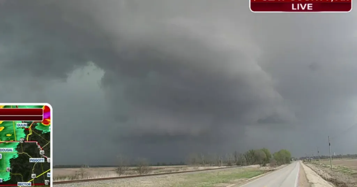
Tornadoes were spotted in several states and the Storm Prediction Center received dozens of wind and hail reports on Sunday. Severe storms also produced wind gusts as high as 85 mph near Hoopeston, Illinois, and 96 mph in Sandstone, Michigan.
As the strong cold front driving Sunday’s severe storms charges eastward overnight and through Monday, some 92 million people from the Northeast southwestward to the central Gulf Coast region will be threatened by another round of severe weather to kick off the new workweek.
Where is severe weather happening now?

(FOX Weather)
The Storm Prediction Center issued Tornado Watches for parts of several states as the major storm system barrels across the Midwest and Tennessee Valley.
Additionally, Flash Flood Emergencies were issued Sunday afternoon for parts of northern Jackson County in southern Mississippi after emergency management reported that roads were impassable in the area. According to the NWS, between 6 and 8 inches of rain had fallen, and an additional 2-4 inches was possible.
WATCH VS. WARNING: HERE ARE THE DIFFERENCES BETWEEN THESE WEATHER TERMS THAT COULD SAVE YOUR LIFE
 A look at Tornado Watches and Severe Thunderstorm Watches issued across the country.
(FOX Weather)
Where are severe storms expected on Monday?
Strong to severe thunderstorms packing threats of fairly widespread damaging winds and several tornadoes are expected on Monday from portions of the Northeast southwestward to the central Gulf Coast region.
The SPC has posted a level 2 out of 5 severe weather risk that stretches from central and upstate New York to southeastern Louisiana. However, a level 3 out of 5 severe weather risk covers much of the mid-Atlantic and Southeast, from Virginia to Alabama.
TORNADO SAFETY: HOW TO IDENTIFY THE SAFEST PLACES INSIDE YOUR HOME

(FOX Weather)
While the highest concentration of wind damage is forecast to be centered over parts of Virginia, the Carolinas, Georgia, Alabama and the Florida Panhandle, a notable threat extends up much of the East Coast, including major cities along the Interstate 95 corridor such as Washington, Baltimore and Philadelphia.
The damaging winds could take down trees and power lines, potentially causing widespread power outages in some areas.
DOWNLOAD THE FREE FOX WEATHER APP
 These maps shows the tornado, damaging wind and large hail threats on Monday, March 31, 2025.
(FOX Weather)
Another severe storm threat looms for midweek
By midweek, more severe weather is predicted to emerge over many of the same regions that were expected to be hit hard on Sunday.
The threat begins overnight Tuesday from central and northeastern Kansas eastward to northwestern Illinois, where large hail will likely be the main severe risk.
Wednesday’s severe weather risk area is eerily similar to Sunday’s, stretching from the southern Great Lakes region to Texas and Louisiana. Damaging winds, large hail and tornadoes are all potential hazards from the severe storms.
ADVICE FOR DEALING WITH STORM ANXIETY WHEN SEVERE WEATHER THREATENS
Additional severe thunderstorms are also possible on Thursday in a corridor stretching from Ohio and western Pennsylvania southwestward to the Ark-La-Tex region.

(FOX Weather)