LOS ANGELES – A powerful atmospheric river storm is pounding parts of California with torrential rain, strong winds and snow that are leading to issues from San Francisco to Los Angeles, including areas recently impacted by deadly wildfires.
In addition to the rain and snow, severe weather has also been a problem.

(FOX Weather)
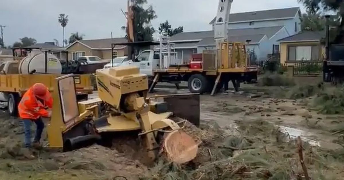
The National Weather Service office in Los Angeles said an EF-0 tornado tore through the El Rancho neighborhood in Pico Rivera early Thursday morning. According to the preliminary report, the tornado had winds of 85 mph and was on the ground for about a mile.
The tornado also left behind damage, including several downed trees and exterior damage to homes.
Video from Thursday afternoon showed crews in Pico Rivera working to remove the downed trees and clear debris.
No injuries have been reported.
Also amid the torrential rains in Southern California, the Orange County Fire Authority conducted a swift water rescue Thursday morning after a man was found clinging to a tree in a rushing creek in San Juan Capistrano. Video showed rescue crews rappelling down from a helicopter to pull the man to safety.
SEE IT: CALIFORNIA MAN SAVED FROM RAGING FLOOD IN DARING HELICOPTER RESCUE
Earlier this week, officials in communities around burn scars created by wildfires such as the Eaton and Palisades fire in January issued mandatory and voluntary evacuations due to concerns about debris flows and mudslides that could threaten homes and businesses due to the heavy rain.
Those fears came to fruition near the Lake Fire burn scar in the Santa Barbara area.
BEFORE AND AFTER IMAGES SHOW THE EXTENT OF WILDFIRE DAMAGE AROUND LOS ANGELES
The Santa Barbara Office of Emergency Management told residents in communities near the Lake Fire burn scar to shelter in place Wednesday night due to flooding and debris flows that were imminent or occurring. That order was canceled early Thursday morning.
Mudslide rescues take place in San Jacinto
Multiple mudslides were reported in the city of San Jacinto on Thursday morning, trapping drivers in their vehicles.
According to information provided by CAL FIRE and the Riverside County Fire Department, multiple mudslides were reported just after 6 a.m. PT, and were covering the road at the intersection of Soboba Road and Chabela Drive. Officials said several vehicles were trapped with people still inside. Swift Water Rescue teams were able to walk out six people who were all evaluated by paramedics on the scene and were released.
SEE IT: CAMERA SHOWS FLORIDA TORNADO BARRELING TOWARD FOX 35 ORLANDO TV STATION
Evacuation warnings were also issued in Malibu, and those were expected to remain in effect until at least 6 p.m. local time Thursday. All Malibu schools were closed Thursday due to the countless road closures across the region.
Among the road closures was the iconic Pacific Coast Highway, which Caltrans District 7 officials said was fully closed from Chautauqua Boulevard and Carbon Beach Terrace due to the threat of mudslides and debris flows.
Evacuation warnings were also issued by the San Bernardino County Sheriff’s Department, and residents were offered sandbags ahead of the storm in an attempt to limit potential damage.
The Los Angeles Fire Department also issued some evacuation warnings for some neighborhoods near burn scars associated with the Palisades, Sunset and Hurst wildfires.
Homes that were in the warning areas were visited by members of the Los Angeles Police Department, and flyers warning of the potential danger were left at homes where no one was available.
The Sierra Madre Police Department said evacuation warnings and evacuation orders have also been issued, and some parking restrictions have also been implemented.
Severe thunderstorms rock San Francisco Bay Area
Northern California wasn’t immune from the impacts of the atmospheric river either.
A wind gust hit 59 mph at San Francisco International Airport Wednesday afternoon as showers and thunderstorms swept through.
Severe Thunderstorm Warnings covered the San Francisco city area Wednesday afternoon for frequent lightning, strong gusts, pea-sized hail and even a possible tornado – rare for the Pacific coast, where severe weather is rare. It was the second Severe Thunderstorm Warning of the year so far to cover downtown San Francisco. The last time the city saw two Severe Thunderstorm Warnings in one year was Aug. 16, 2020, according to the FOX Forecast Center.
DOWNLOAD THE FREE FOX WEATHER APP
Rain continues through workweek
 This graphic shows the forecast rain totals in Southern California.
(FOX Weather)
Computer forecast models show as much as 1-4 inches of rain falling during the remaining days of the workweek, which could lead to flooding and additional mudslides.
Burn scars from wildfires often trigger mudslides and flooding, as the soil in affected areas struggles to absorb water and leads to runoff. Residents across Southern California are being urged to stay vigilant by having multiple ways to receive alerts in case conditions quickly worsen.
EXPLAINING FLOOD ALERTS ISSUED BY NATIONAL WEATHER SERVICE
While it is late in the season for atmospheric river events, locals said they’ll take as much rainfall as they can, with the calendar year quickly approaching the start of California’s typical dry season, which begins in late spring.
Heavy snow also causing problems
In addition to heavy rainfall, snow levels are expected to drop significantly in the Sierra Nevada Mountains, with several inches to several feet of snow anticipated at higher elevations. According to computer forecast models, up to 3-4 feet of snow is expected to accumulate, helping to create an enhanced snowpack in areas where it has been below average this season.
A Winter Storm Warning is in place for the Sierra Nevada, including Yosemite Valley. Gusting winds up to 60 mph and up to 18 inches of snow are making travel difficult in the mountain passes.
California Highway Patrol temporarily closed U.S. 50 on Thursday at Echo Summit for avalanche control.
In Olympic Valley, Palisades Tahoe ski resort reported 25 inches of snow Thursday morning, with forecasts calling for 8-12 more inches by the end of the day.