Millions in the Upper Midwest face the possibility of a severe thunderstorm outbreak Monday that could bring rounds of dangerous storms capable of unleashing damaging winds, large hail and strong tornadoes — the start of several days of extreme weather threats across the country this week.
The first batch of severe thunderstorms is expected to take shape in the Upper Midwest in the afternoon. Damaging storms are also possible in parts of the Mississippi Valley and Plains, putting more than 35 million people at risk of dangerous weather from Texas to northern Minnesota. Tens of millions more could be in the path of severe thunderstorms Tuesday as the potent storm system driving Monday’s threat surges east.
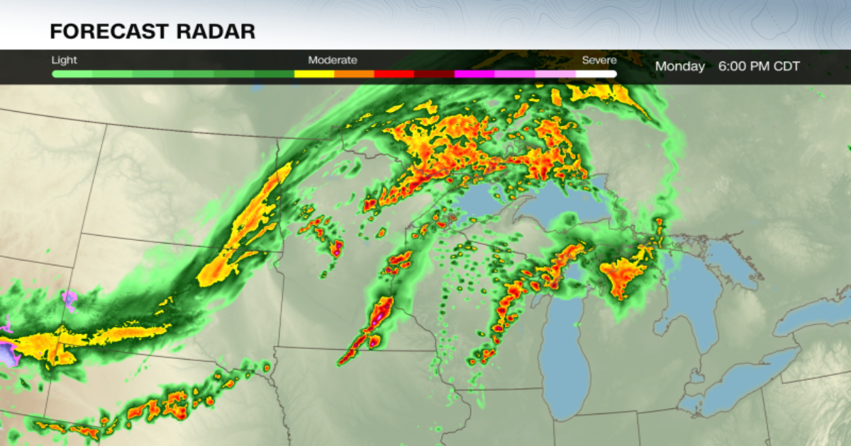
A few thunderstorms were ongoing in parts of the Dakotas and Upper Midwest early Monday morning, but the threat of ferocious storms will increase in the same areas by the afternoon.
Storms in parts of Minnesota, Wisconsin and Iowa – where a level 4-of-5 risk of severe thunderstorms is in place, according to the Storm Prediction Center — could become the most dangerous of the day. The cities of Minneapolis and St. Paul are under this risk level.
Strong tornadoes — rated EF2 or greater — are possible for areas under the SPC’s level 4-of-5 risk and for some areas within its level 3-of-5 risk. The late afternoon and evening will be the “most dangerous period” when “strong tornado potential should be maximized,” the SPC warned.
Thunderstorms could arrive in two waves in some of these areas, with each round packing its own serious punch.
Storms could fire up in the afternoon ahead of an advancing cold front and quickly become violent supercells — essentially the most extreme form of thunderstorm. All the necessary atmospheric ingredients are in place to fuel supercells and a serious tornado threat, but it will depend on if storms are actually able to form ahead of the front.
Even if they don’t, the Upper Midwest will see a round of powerful thunderstorms roar to life by Monday evening as the cold front slices through.
This line of storms could unleash widespread damaging wind gusts, hail and tornadoes. While these tornadoes may not be quite as strong as any spawned by the supercells, they will still pose a great danger.
Minnesota and Wisconsin haven’t reported a single tornado this year, though that could change in an instant Monday.
Other parts of the country have been extremely active: At least one tornado has occurred somewhere in the United States each day for nearly two weeks straight. This year is also pacing at the second-highest number of tornado warnings on record to date – only behind 2011.
Other thunderstorms could rumble to life later Monday afternoon and evening from Kansas and Missouri to Texas. Some of these storms may not be as fierce as those farther north, but could still deliver powerful wind gusts, large hail and tornadoes.
Some of Monday’s thunderstorms will continue overnight and into early Tuesday morning, likely losing their potency with time. But a renewed severe thunderstorm threat will unfold Tuesday afternoon.
A vast swath of the country more than 1,800 miles long from West Texas to Vermont is within a level 2-of-5 risk of severe thunderstorms on Tuesday, with a smaller but more significant level 3-of-5 risk for parts of Ohio, Pennsylvania and New York.
It’s a setup putting more than 45 million people at risk of dangerous weather.
Thunderstorms could develop in the afternoon in parts of Texas and Oklahoma while farther north, the same system that brought Monday’s severe weather ignites new storms in Canada and parts of the Midwest.
Storms that develop Tuesday afternoon will likely start in southern Ontario and then track into parts of Ohio, Pennsylvania and New York in the evening. Damaging wind gusts are the main threat with these storms, but some could drop large, egg-sized and tornadoes.
A flash flood threat will build in tandem with Tuesday’s storms in the Plains and Mississippi Valley.
A level 3-of-4 risk of flooding rainfall is in place Tuesday for portions of Texas, Oklahoma — including Oklahoma City — Kansas and Missouri, according to the Weather Prediction Center.
Heavy rain late last week and over the weekend drenched the ground in these areas, making them much more vulnerable to new bouts of soaking rain. Those storms caused flash flooding that turned deadly the prior weekend in Oklahoma.
Stormy weather and periods of heavy rain will persist Wednesday, with a level 3-of-4 risk of flooding rainfall in place for parts of Texas, Oklahoma, Missouri and Arkansas.
A few severe thunderstorms are possible in the southern Plains on Wednesday, but chances for disruptive storms start to fade for the rest of the week.